Friday, September 29, 2006
Norway sends a welcome message to the trusted partners...
NORWAY has advised the Zambia Wildlife Authority (ZAWA) to actively share its vision, successes and problems with key partners to continue being a trusted partner
The Post 29 September 06

Some word at the end left out are:
...not to mention their habitats, are not unduly endangered by human activity
edjokotoe@yhoo.com
Efforts are being made to obtain some sort of comment from AWF, a query being sent to its President in Washington, Patrick Bergen, concerning the conflicting views and actions taken by their trustee, Chief Mukuni, of the AWF created Mukuni Trust. It would also be nice to hear from WWF and IUCN
Thursday, September 28, 2006
Norway propping up ZAWA...
Wednesday, September 27, 2006
ZAWA receives 25 motor vehicles
By Times Reporter
NORWAY has advised the Zambia Wildlife Authority (ZAWA) to actively share its vision, successes and problems with key partners to continue being a trusted partner.
Norwegian ambassador to Zambia, Terje Vigtel, said the embassy was encouraging transparency and openness, a shift from policing to dialogue with local communities on borders with protected areas, and the devolution of authority to field offices.
Mr Vigtel was speaking yesterday during the handover of 25 motor vehicles donated by the Norwegian government and the World Bank under the Seed project.
“On this particular occasion, the World Bank and Norway are here to officiate the handing over of over 25 motor vehicles to be used in Kafue, Mosi-oa-Tunya and South Luangwa National Parks, all valued at US$578,000.”
From the Norwegian experience with the wildlife sector in Zambia, there was a lack of coherent guidance resulting from frequent changes coupled with improper instructions from management.
Mr Vigtel advised ZAWA to establish a strict monitoring scheme regarding the use of the vehicles to benefit the intended programmes.
He said he was happy with the growing number of dedicated lodge owners in the park and surrounding areas who had invested in high-quality tourism activities resulting in many employment opportunities.
Tourism ministry Permanent Secretary Russell Mulele appealed to cooperating partners to consider expanding their support to other wildlife estates in Zambia.
Mr Mulele said the support from cooperating partners had greatly reduced poaching in Kafue and other national parks.
Wednesday, September 27, 2006
Mukuni Trust...

The Mukuni Trust was one of five community trusts created by the African Wildlife Foundation as part of the Kazangula Heartlands Project. While Chief Chikuni supports the Legacy proposed development, AWF has remained silent on the matter.

A Vice-President in waiting says...
Sakwiba denounces L/stone hotels project
By Times Reporter
UNITED Liberal Party (ULP) president Sakwiba Sikota (above) has said the US$200 million investment by Legacy Group to build two five star hotels and a golf course should not be allowed in the Mosi-Oa-Tunya National park as it will disturb animal movement and distort the environment.
Mr Sikota said the project would ruin the national heritage.
Speaking at a Press briefing in Livingstone yesterday, Mr Sikota said people’s fears about the effects of the investment on the environment and animals were justified and advised the project be taken elsewhere.
“Twenty six days from now, you will have a sensible government which will stop that project. If by chance we do not take over government, we will go to court and stop the development,’’ Mr Sikota said.
Vice President Lupando Mwape last month commissioned the foundation stone in Livingstone and the Legacy Group is currently conducting an environmental impact assessment.
At a recent meeting aimed at seeking people’s views on the location of the project, several stakeholders opposed the location of the investment in the park saying it should be taken elsewhere, with likely minimal distortion to the environment and disturbance on animals’ welfare.
He said Government had shown clearly that it cared more about money than the people by allowing investors to invest in wrong places.
He claimed that Sun International had taken the space occupied by three hotels and fenced off thereby disturbing the movements of animals, especially elephants which resorted to using the cultural village route, where the Legacy foundation stone had been erected.
“We have heard stories of some people being trampled by elephants, it will even be worse,’’ he said.
Mr Sikota said it was wrong for Government to allow destruction of the environment for money and called for morality on the part of leaders.
Tuesday, September 26, 2006
VICTORIA FALLS LEGACY ...I. P. A. Manning
The interview on 19 September by John Robbie - a talk-jock at Radio 702 Joburg, of David Gleason (gleasontorque.com, publisher, financial editor & journalist, former senior bwana at mining group, Anglo American in Zambia, former Chairman of the Wildlife and Environmental Society of Zambia, organizer of the funding for the Black Lechwe project...), had a bit of rugby about it: a hard pass from the former Greyhounds and Ireland scrummie smacking Gleason in the eye, being introduced by Robbo as “the former columnist with Business Day who was fired and now has his own independent column”, then being given a sound bite to express his concern at the proposed Legacy move of two hotels, a golf course and 300 or so riverside chalets into our tiny Mosi oa Tunya National Park in Livingstone, Zambia, the equivalent of Legacy Hotels moving their Sandton Michael Angelo hotel out to Joburg Zoo Lake under a bit of enrichment camouflage. This brief engagement with a carrier of environmental and business concern was followed, after an agonizing assault of advertising and an interesting interview of an attorney on credit issues, by a soft, slightly forward pass from Robbo right on the tryline to good old Bart Dorrenstein ranging up alongside, Legacy’s Big Man ‘imself, “Good to see you again, Bart Dorrenstein, now what is this all about....?” Bart replies, kindly, reasonable, bending doubtless forward in unctuous capitalist sincerity – “No, no...we have had no dealings with politicians, only the Zambia Wildlife Authority (ZAWA). Of course, I did meet the Zambian President, a fine gentleman, but only in a group. And of course we are submitting an environmental impact assessment, and so on...” And so on. And no more Gleason...did he have to hang on to the phone for an hour while all this was going on? Finally, Robbo, in a repeat of the time he and old Nasty Booter and good old Dan Retief were gathered on the DSTV rugger programme, Boots and All, to give whatfor to the Griqua Emperor-President of the South African Rugby Union, the formidable nut-squeezer of Griqua scrums, Brian van Rooyen, but then deciding through a pheromone infusion process that driver ants use to communicate, that discretion and a bit of sycophancy was collectively in order, sums up by saying, “Well, Bart, good luck with the project!” Nice.
Not much here, really. Except that on Saturday 29 July 2006, - before the go-ahead of the Livingstone Town Council, the National Heritage Conservation Commission, the Environmental Council of Zambia and the people of Livingstone and other operators – let alone UNESCO, who are in charge of World Heritage Sites, had been obtained, Vice-President Lupando Mwape of Zambia laid the foundation stone of the Legacy Holdings, Mosi-oa-Tunya Hotel and Golf Estate development in the World Heritage Site in Livingstone, assuring the gathered notables (Chairman of Legacy Holdings Zambia , J.J. Sikazwe, who ushered in the Citizens Economic Empowerment Act into Zambia; Renatus Mushinge, the Legacy Holdings Development Director and brother of the Financial Director of the Zambia Wildlife Authority, Tom Mushinge – who issued the TCA (Tourism Concession Agreement) to Legacy; and Bart and other Legacy Joburg Directors, of course) that “Those who have been hero-worshipped somewhere else based on misdirected superiority complex will not be worshipped in Livingstone” referring to paleface tourist operator investors who because of a precipitous fall in the dollar were having to reduce staff, now appearing so infinitesimally small and mean-spirited in the glare of the Legacy empowerment boast that they would provide permanent employment for 1000 Zambians. Now who put the Veep up to this one?
And the Environmental Council of Zambia, as of yesterday, had still not received the EIA from Legacy, promised them at the end of August, and there is no news from our Livingstone team of the long awaited scoping exercise which requires that civil society be consulted. And the recent five-day Mosi oa Tunya National Park workshop held by ZAWA was abysmal by all reports, the organizers announcing in the middle of the workshop that they were putting out more lodge sites for tender in the Park and could not wait for the finalization of a park management plan in order to do so.
Now the thing is that we all want Legacy to come to Livingstone, but not in the Park, not close to Livingstone so that their projected 300 000 visitors a year will bring all traffic to a standstill on the one road available, lock-out for ever the people from an area used by them for a few centuries and block for all time the main elephant migration route. There is an alternative site available. Why don’t Legacy do us all a favour and pack their wagons and trek over there?
Temporary cancellation of tourism leases...
Yesterday ZAWA posted an advert cancelling its tender for numerous tourism leases in National Parks - about four of them in Mosi oa Tunya, saying that the ad would soon reappear.
Sunday, September 24, 2006
Sikazwe of Legacy Holdings...
The Times. Zambia
Thursday, September 21, 2006
11 picked to serve as citizens economic empowerment commissioners
By Times Reporter
PRESIDENT Mwanawasa has appointed 11 Zambians to serve on the Citizens Economic Empowerment Commission.
State House legal advisor Darlington Mwape said the commission to be chaired by a Mr J Sikazwe includes Secretary to the Treasury Evans Chibiliti, Commerce Permanent Secretary Davidson Chilipamushi and Labour Permanent Secretary Ngosa Chisupa.
Others are Ms Chipili Katunasa, Efreda Chulu, Prisca Sikana, Ian Mkandawire, David Samutela, Stephen Moyo and Chola Kafwabulula as commissioners.
Mr Mwape said the main function of the commission would be to promote the empowerment of citizens that were marginalised or disadvantaged.
Beneficiaries would include those whose access to economic resources and development capacity has been constrained because of various factors such as race, sex, educational background, status and disability.
“The commission shall among other things ensure equal opportunities for all and where necessary ensure preferential treatment to targeted citizens, citizens empowered companies, citizens influenced companies and owned companies,” Mr Mwape said.
He said this was done in accordance with Section 7 (1) of the Citizens Economic Empowerment Act number 9 of 2006.
Friday, September 22, 2006
ZAMBIA NATIONAL BROADCASTING CORPORATION says...
Mosi oa Tunya Workshop
ZAWA's new plan for Livingstone
The Zambia Wildlife Authority (ZAWA) has pledged to develop a comprehensive General Management Plan for the protection and development of the Mosi-Oa-Tunya National Park in Livingstone.
ZAWA Head of Protected Areas, Zook Muleya said a General Management Plan is important to ensure, there is transparency and accountability in the way the Mosi-Oa-Tunya National Park is managed.
Mr. Muleya was speaking in Livingstone, at the close of a five day workshop.
The workshop was organized by ZAWA, which is developing a new General Management Plan to replace the draft plan that has raised a number of controversies on how the Mosi-Oa-Tunya National Park is managed.
Senior Chief Mukuni of the Toka-Leya people said ZAWA has been using an outdated and draft General Management Plan that needs to be updated to suit the new development challenges.
The Chief said the heritage status of the Mosi-Oa-Tunya National Park must be recognized in the management plan and stressed the need to involve the local people.
ZNBC
PROPOSED ZONING OF MOSI OA TUNYA NP
We now have here the final report prepared by Clare Mateke on the ZAWA workshop - held recently over five days, to prepare a management plan for the Mosi oa Tunya National Park
DAY FIVE OF MOSI OA TUNYA WORKSHOP 11-15 SEPT.
DAY FIVE
STRATEGIC INVESTMENT MANAGEMENT ACTION PLAN AND BUDGET
The first half of day five was spent in group discussions to come up with a strategic investment management action plan and budget. This included the following:
For each problem highlighted on Day 3, the groups had to come up with:
- Objective
- Action
- Activities
- Strategy/How the activities are to be done
- Materials and experts
- Location of activities
- Organisations involved
- Time frame
- Priority rating
- Estimated cost
- Possible sources of funding
- Possible constraints
As this information is very extensive, only the Problem, Objective, Action and Activities have been included in the report below. Not that the list is not complete as the reporter was unable to take complete notes on all the group reports.
NATURAL RESOURCES
1. Problem: High rate of road kills
Objective: To reduce road kills to a minimum
Actions: Introduce speed control measures
Activities:
i) Increase signage within the park and approaching the gates on main roads – including barrier signs, slow down signs, speed limit signs and animal warning signs.
ii) Introduced Speed traps on main roads
iii) Clear vegetation, particularly undergrowth along sides of main roads for clear view by motorists
2. Problem: Inbreeding
Objective: Control levels of inbreeding
Action: Reintroduce animal species that have very low numbers or show signs of inbreeding.
Activities:
i) identify species which are inbred by carrying out research (genetical, population studies, physical assessment, literature research)
ii) Introduce new stock of animal species which are found to be inbred or in very low numbers
3. Problem: Littering
Objective: To reduce littering in the park to minimal levels
Action: To initiate a waste management programme
Activities:
i) Construct waste disposal sites in neighbouring residential areas in conjunction with Livingstone City Council.
ii) Initiate awareness campaigns within residential areas and with transport operators.
4. Problem: Habitat destruction
Objective: To reduce habitat destruction to minimal levels
Actions: i) Review international conventions on elephant culling and carry out research
ii) Control and monitor tourism development and human activity in the park.
Activities:
i) Make proposals on elephant control to international bodies
ii) Collaborate with neighbouring countries to conduct research on elephant movement and the possibility of creating transfrontier parks
iii) Constant supervision and monitoring of construction works
iv) Increase patrols
5. Problem: Bush fires
Objective: To prevent the occurrence of bush fires in the park
Action: Put in place and implement a fire management plan
Activities:
i) Create fire breaks along park boundaries
ii) Carry out awareness campaigns in communities on the effects of bush fires
iii) Constantly monitor fire outbreaks by satellite
iv) Recruit more staff for fire patrols
v) Train staff in fire management and fire fighting
vi) Carry out regular fire patrols
vii) Acquire fire fighting equipment
6. Problem: Soil Erosion
Objective: To restore eroded areas and prevent further soil erosion
Action: Put in place soil erosion control measures
Activities:
i) Re-vegetate eroded and cleared areas
ii) Fill in gullies with stones using gabion wires and scour checks where necessary
iii) Improve drainage system along roads
7. Problem: Shortage for food for grazers in parts of the park.
Objective: Improve food supply
Action: Put in place and implement a programme to improve grass and herb production.
Activities:
i) Expand irrigation system and improve water distribution
ii) Carry out research on soil fertility, plant and animal productivity, animal carrying capacity and health of plant and animal populations and biodiversity of plants and animals
iii) Improve movement of animals throughout the whole park.
8. Problem: Noise Pollution
Objective: Reduce noise levels to a minimal level
Action: Put in place a noise pollution control programme
Activities:
i) Revise and implement aviation control measures
ii) Implement boating control measures
iii) Frequently monitor park users for noise levels
iv) Revise licensing system for plane, helicopter and boat licenses
MANAGEMENT AND OPERATIONS
1. Problem: Poor Coordination between stakeholders
Objective: To introduce a joint management programme for stakeholders
Action: Establish stakeholder consultative committees
Activities:
i) Identify all focal persons in interest groups in sustainable management
ii) Draw up terms of reference for consultative committees
2. Problem: Inadequate training and low staffing levels
Objective: To improve recruitment and manpower development
Action: i) Carry out training needs assessment
ii) Review existing staff structure
Activities:
i) Identify appropriate courses and training institutes
ii) Hire trained staff
3. Problem: Absence of ratified General Management Plan, leading to unplanned development in the park.
Objective: Designate development zones
Action: Adequate consultation with stakeholders
Activities:
i) Hold meetings with stakeholders
ii) Develop a General Management Plan
4. Problem: Poor road infrastructure in the park
Objective: Improvement of road infrastructure
Action: Upgrade existing road infrastructure
COMMENTS
1. Some participants expressed concern at the poor turnout of stakeholders at the workshop, particularly from the private sector. It was explained that at least three tour operators had been invited, but none had turned up.
2. There was a suggestion that the Ministry of Tourism write to the tour operators about this – which implied a lack of interest by the tour operators in the management and problems of the park.
3. A participant was concerned about the issue of animals straying into human settlements.
VISITOR USE AND EXPERIENCE
1. Problem: Visitor Expectations not fully met
Action: Provide adequate security and safety measures
Activities:
- patrols
- warning signs
- patrol boats
- life jackets
- first aid equipment
- fire extinguishers
- police post in the park
2. Problem: Stiff competition
3. Problem: Local Access
4. Problem: Park not aggressively advertised
Action: Develop aggressive marketing strategy
5. Problem: Littering
Activities:
i) Provide waste bins
ii) Litter collection
iii) Sensitise communities
6. Unfriendly Customer Care Services
Objective: Create friendly atmosphere
LOCAL COMMUNITY MANAGEMENT
1. Problem: Local Community not involved in decision making and benefit sharing
Activities:
i) Outreach programme
ii) Sensitisation
iii) Stakeholder meetings
iv) Educational materials
v) Sponsoring traditional ceremonies
2. Problem: Lack of access by community for firewood, crafts and grazing
Activities:
i) Create a buffer zone
ii) Shift electric fence inwards in some places
iii) Relocate plots which are within the park boundary
iv) Sensitisation
v) Stakeholder meetings
3. Problem: Human – wildlife conflict
Activities:
i) erect electric fence round whole park
ii) erect electric and chilli fences around settlements and farms
iii) lobby for elephant hunting quota
4. Problem: Lack of alternative watering points for domesticated animals outside the park during the dry season.
Activities:
i) sink boreholes
ii) build dams
iii) carry out research to identify appropriate sites for the above activities
5. Problem: Lack of alternative routes from Mukuni Village to town
Activities:
i) create bypass road from Mukuni Village to Libuyu township
COMMENTS
1. Fencing of the park is a big development and should have required an EIA.
HERITAGE RESOURCE MANAGEMENT
1. Problem: Crumbling walls of the pit in the field museum (due to the effects of a fire)
Activities: Chemical treatment of the walls by drilling
2. Problem: High erosion of in-situ cultural heritage sites
Activities:
i) Erect erosion barriers around affected sites
ii) Re-vegetation of eroded areas
3. Problem: Vandalism of sites by humans (especially removal of plaques)
Activities:
i) sensitisation
ii) repair and maintenance
4. Problem: Destruction of sites by wildlife (particularly the Old Drift Cemetery)
Activities:
i) chilli fencing around sites
ii) re-building and restoration
iii) painting built-up sites with environmentally friendly colours or no paint at all
5. Problem: Conflicting legislation in the area
Activities:
i) Harmonise conflicting legislation
ii) Stakeholder collaboration – quarterly consultative meetings with all stakeholders
6. Problem: Lack of financial benefit to the local community from heritage sites
Activities:
i) put in place resource-sharing modalities
ii) engage communities to draw up memorandums of understanding on resource utilisation
iii) meetings with local authorities
iv) review legislation
7. Problem: Lack of interpretation and publicity of heritage sites
Activities:
i) Urge NHCC to provide more information about the sites in the park
ii) Provide required data and interpretation
iii) Erect information billboards
iv) Replace vandalised plates
v) Produce brochures
COMMENTS
1. Are chilli fences allowed in the park? ZAWA would have to decide. There was a proposal to use sharp stones or spikes in the ground, not chilli fences, although this had not worked around the Sun International hotels.
2. It was emphasised that the original form of the graves should be preserved as much as possible when carrying out restoration activities.
3. A question was raised as to what measures were being put in place to protect graves near the river which may flood them. There were no measures identified.
4. It was pointed out that the problem of crumbling walls of the pit in the field museum was being added to by water seepage from the ZESCO power station.
5. There was a proposal to improve the design and structure of heritage monuments to make them more durable.
6. A request was made that before fencing of the southern part of the park, ZAWA should sensitise Songwe Villagers on the proposal, to prepare them.
7. The issue of encroachment of settlements into the park had been left out by mistake.
8. It was clarified that a Memorandum of Understanding between NHCC and ZAWA was already in place, but the problem seemed to be in its implementation.
9. It was clarified that the current Heritage Act did not allow for local financial benefit.
PRIORITIES
There was some discussion on defining priority levels for the highlighted activities. In the end no agreement was reached about defining priority levels, but the following proposal was made for defining the length of projects:
Short term – up to 2 years
Medium term – up to 5 years
Long term – up to 10 years
It was also agreed that the priority ratings should be revisited every 3 years.
ANOTHER ZONATION PROPOSAL
At the end of the meeting, the second zoning proposal as requested on Day Four was presented to the participants as follows:
SECOND PROPOSAL FOR MOTNP ZONATION
1. Zero Development and Restricted Use Zone
2. Development Zone
3. Natural Preservation Zone
1. ZERO DEVELOPMENT AND RESTRICTED USE ZONE
Location: Victoria Falls, Zambezi River, Islands, Gorges, Maramba River, and a buffer zone of at least 50m along Zambezi and Maramba Rivers and more along the Gorges
Justification: These are exceptional resource values which form the sole of the park, on which the purpose is based, and should be strictly protected at all costs
Acceptable Use: Zero development, construction, destruction, strictly regulated tourists activities such as boating, rafting, etc.
2. DEVELOPMENT ZONE
Location: SWSC Water Intake Plant to David Livingstone Lodge; Sun Hotel complex, and ZESCO Power Station.
Justification: These are already built up, and some of the developments existed long before the creation of the park, and cannot now be removed.
Acceptable Use: Limited to existing developments, with strict regulations.
3. NATURAL PRESERVATION ZONE
Location: The remainder of the park.
Justification: If the natural resources of the park are destroyed by too much development, it will have no value left and might as well be degazetted.
Visitor use: Few provisions of accommodation, otherwise game drives, scenic walks and drives, bird viewing, picnics.
Acceptable Use: Limited development “spots”, with strictly defined size and allowable activities. Rest of area - preserve the “wilderness value/experience” as much as possible, both for conservation of natural resources and for tourist activities. No developments in the World Heritage Site and no more developments along the rivers or gorges, as it is important for these to be preserved for conservation and for wilderness value for tourist and community activities.
Justification for including area on each side of Maramba River up to the Falls in Natural Preservation Zone:
1. It is the only tributary into the Zambezi within the park, and therefore any nearby activities or developments will affect the Zambezi River and the Falls
2. It is close to the Falls, which is the major exceptional resource of the park, and should be protected as much as possible and kept natural.
3. The river banks of both rivers are very important for wildlife, as well as for tourist and community activities, and therefore should be kept undeveloped to that all can benefit from them.
4. This part of the park is the narrowest portion of the park, and if overgrazing and destruction by animals in the central part is to be avoided, the animals have to be allowed to pass into the southern part along this narrow corridor. If it is developed this will not be possible.
5. It is one of the important elephant corridors across the river, and should be allowed to remain as such, to avoid more damage in other areas.
Comment: Development of any kind within the park should NOT be allowed to go ahead before this plan is completed and ratified. How can we allow development without a plan?
COMMENTS
1. A participant said that the proposal seemed to be merely an attack on the proposed Legacy development.
2. Another participant said the proposal for a Zero Development zone was not practical.
3. The participant who had presented the proposal explained that the proposed zonation was not an attack on the Legacy development, but concerned all developments in the park, and took into account the most valuable areas, which should be protected for the wildlife, tourists and local people.
4. It transpired that most participants had not had time to read the justification for the proposed zoning, but merely glanced at the map.
5. It was decided that both proposals would be considered in the preparation of the Management Plan.
CLOSING REMARKS
By Senior Chief Mukuni
In his closing remarks Senior Chief Mukuni thanked ZAWA for casting their net wide and inviting even the local community.
He said the local community recognised the National Park and the World Heritage Site.
He said we should “Manage change, do not let change manage you.”
He urged ZAWA to speed up the ratification process.
By Zook Muleya, Facilitator
Mr Muleya said the workshop was a significant milestone for strategic planning.
He said the GMP should be a useful, dynamic document, which should be continuously revised.
APPENDIX
Participants included representatives from the following:
1. Zambia Wildlife Authority (ZAWA), HQ
2. ZAWA, Southern Command
3. National Heritage Conservation Commission (NHCC)
4. Livingstone Museum
5. ZESCO, Victoria Falls Power Station
6. District Forestry Department
7. Victoria Falls Curio Sellers Association
8. Environmental Council of Zambia, Livingstone
9. Dept of Community Development
10. Livingstone City Council
11. Imusho Village
12. District Veterinary Office
13. District Administrative Office, Kazungula
14. Songwe Village
15. Zambia Air Force
16. Southern Water and Sewerage Company
17. Mukuni Chiefdom
18. Musokotwane Chiefdom
19. Sekute Chiefdom
20. Ministry of Tourism, Environment and Natural Resources
21. Roads Department
DAY FOUR OF MOSI OA TUNYA WORKSHOP 11-15 SEPT.
DAY FOUR
PARK ZONING
Guidelines
Below is a summary of the guidelines given:
Management zoning should: -
- take into account already identified issues, protected area purpose and significance, exceptional resource values and protected area management objective
- identify the location or resources that need the most management and protection
- be based on the identification of the appropriate range of visitor experiences and resource conditions that could exist
- include rationale for why the zones were established
- consider the capability of land to support different land uses, development suitability of different areas, identify those areas sensitive to use and those that can withstand use
- be identifiable on the ground to enable field identification
- provide basis for a monitoring programme
- be used to provide management continuity over time
Guidelines were then given for five categories of zones as follows: -
1. Wilderness Preservation Zones are: -
- areas where the earth and its community of life are unaffected by man; where man is a visitor and all his activities leave no imprint;
- Areas affected primarily by the forces of nature and no noticeable imprint of man;
- Area managed to retain pristine character and undisturbed nature without permanent human habitation
- Provide the highest level of protection to extremely fragile areas and resources
- Provide a bank of resources for the future
- Areas where only limited visitor use is allowed to the extent that undisturbed nature can be maintained; and
- Areas with no private or commercial enterprise; no permanent structures; no permanent roads; no use of motor vehicles, motorboats, or other mechanical transport or motorised equipment; no commercial aircraft landings (except in emergencies involving health and safety of persons in the area).
2. Natural Preservation Zones are: -
- areas that should be managed to conserve natural resources and ecological processes
- areas that provide for appropriate visitor use and enjoyment in ways that do not adversely affect the resources and processes;
- areas where development should be limited to essential facilities and not permitted to sensitive habitats and resources
- areas where the impact of development and use should be minimized; and
- temporary zones that may be created where special management is required to restore natural conditions to areas disrupted by past or present human activity
3. Development Zones are: -
- areas managed to keep the environment as natural as possible but enable high concentration of visitor use, protected area operations and other support facilities;
- areas where mitigation measures are put in place to minimize impacts associated with proposed developments
- areas which should be restricted to the smallest area necessary to accommodate the required protected area development and use; and
- areas where protected area development facilities should be kept separate from visitor use facilities.
4. Heritage Preservation Zones are: -
- areas managed for the purpose of protection, preservation and interpreting of archaeological sites, historical sites, contemporary religious uses and other traditional use sites; and
- areas where traditional uses are allowed at certain times and seasons.
5. Special Use Zones are: -
- areas that have uses carried out by other government agencies or private interests
- areas whose administrative control over the use of land in them is either lacking or secondary to that of the other party/agency; and
- areas whose management emphasis depends on the type of special use and relationship of that area to the protected area.
Emphasizing that: -
- the essence of the management zone plan is to describe what can and cannot occur in the identified management zones
The management zone plan
- outlines the management strategies for each zone
- provides guidance on the actions to be undertaken by protected area management in order to maintain the integrity of the entire zoning scheme
- provides direction for the day-to-day operations and long-term decision-making
The plan should not attempt to maximize on the use of resources.
The Zambian approach to tourism requires low numbers of high paying tourists.
The Limits of Acceptable Use (LAU) system lays primary emphasis on the conditions desired (physical and social), rather than on the maximum amount of use and development the protected area can tolerate.
A list of tasks were identified, of which the house was informed that the following tasks had already been done by a group of ZAWA and NHCC staff after the previous day’s meeting:
1. Determine the number of zones for the park.
2. Delineate the appropriate determined management zones under 1 above
3. Suggest and determine appropriate names of the management zones delineated under 2 above.
A map of the zones proposed for the park was presented.
The following zones had been proposed:
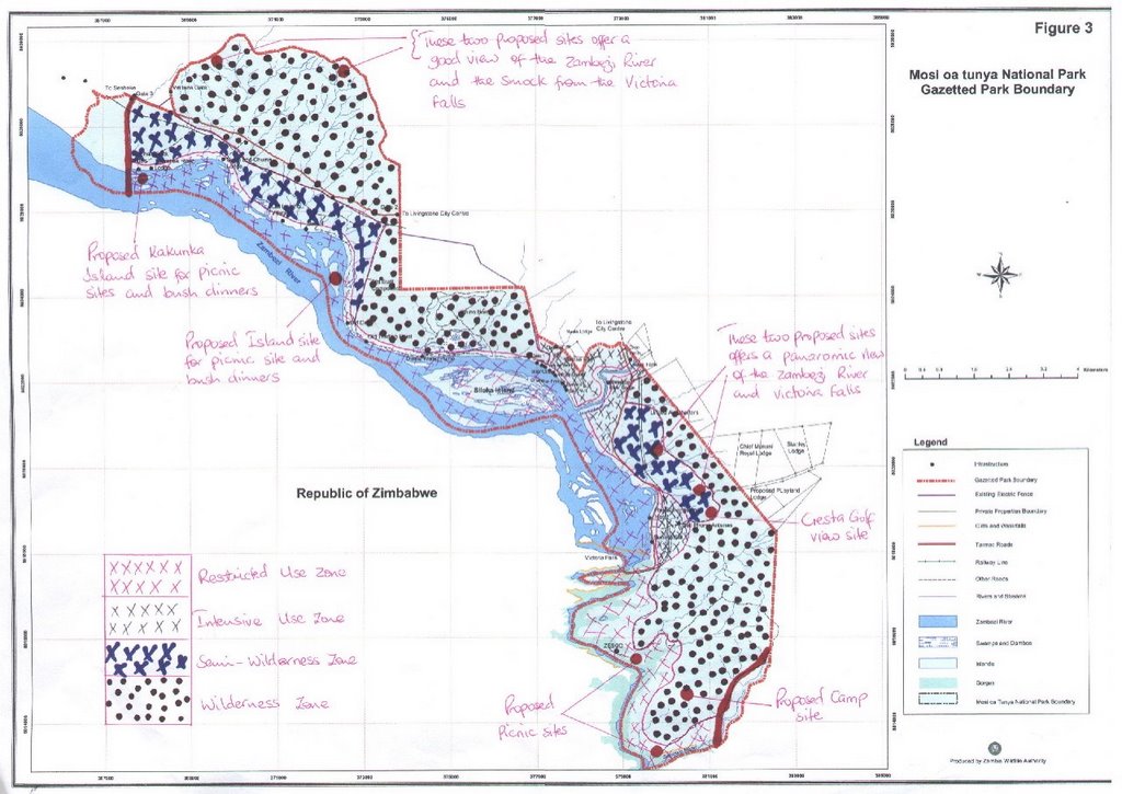
1. Restricted Use Zone
- Zambezi River, with a 50m buffer
- Maramba River, with a yet to be defined buffer
- Gorges, with a wider buffer margin
- Islands in Zambezi River
2. Intensive Use Zone
- Sun International area
- Proposed Legacy hotels and Golf course area (minus the 50 m buffer along the rivers)
- Crocodile Farm
- Nawa Farm
- Saf Par upcoming David Livingstone Safari Lodge, Bwaato, Waterfront, etc up to Park entrance
3. Semi-wilderness Zone
- Area between Hubert Young Drive and Falls road (includes three proposed tourist development sites, including Cresta Golf View Site)
- Area between track road (parallel to Nakatindi Road) and Zambezi River from picnic site at end of Riverside Drive up to western end of park (Thorntree Lodge).
4. Wilderness Zone
- Rest of park, including north end - Nakatindi Road and north to Knight’s Drive, Zoological park, and whole of southern end of park.
Comments
1. A participant asked why the names of proposed zones did not follow the ones in the guidelines. It was explained that these were alternative names to the ones given, and that the guidelines did not have to be followed exactly.
2. A participant asked what the meaning of Restricted Use was. It was explained that this would be answered by the group dealing with this zone.
3. A participant asked what the justification for the delineation for the Intensive Use Zone was. It was explained that this area was already used a lot and therefore it should be classified as Intensive Use.
4. It was explained that some of the proposed development sites had been changed. This had occurred after the discussion on proposed zoning the evening before, and the proposed changes had already been sent to ZAWA headquarters the same night, in order to change the advertisement which was to come out in the press the following day.
5. A question was raised about the lifespan of the General Management Plan. It was explained that once it was ratified, the plan would run for 10 years, subject to review every 3 years.
6. When asked why the advertisements for development sites could not wait until the plan was in place, the facilitator explained that developments had to go ahead and could not wait for a plan.
The participants were then requested to proceed to the next steps as follows (for each zone):
1. Describe the natural resources status of the zone
2. Define the zone purpose
3. Prescribe the accessibility
4. Identify the visitor use and experience
5. Identify and list the developments or permissible developments of the zone, and
6. Determine the limits of acceptable use
Group 1
RESTRICTED USE ZONE
a) Natural Resources Status
- Islands have fragile soils, i.e. weak land mass
- Fairly intact riparian vegetation
- Fairly undisturbed aquatic life
- Steep river bank
- Fairly abundant wildlife
- Abundant water resource
- Gorges still in good natural condition
b) Purpose
- To ensure preservation of fragile soils and vegetation on the islands, while allowing minimal sustainable development or use.
- Conservation of the river catchment area
- Regulate the use of the river, falls and gorges to ensure sustainability of enhanced visitor experience
c) Accessibility
- by water transport
- by footpaths, gravel and surface roads to the river catchment area
d) Visitor use and Experience
i) Islands
- picnics
- bush dinners
ii) Zambezi River
- boating and canoeing
- sport fishing and angling
iii) Gorges
- bunji jumping
- gorge swinging
- rafting
- gorge viewing via cable cars
iv) Falls
- viewing
e) Permissible Developments
i) River
- picnic site infrastructure, i.e. waste management, bins, toilets
- boat jetties
ii) Gorges
- cable car infrastructure
iii) Falls
- visitor information centre
- trails
- litter bins
- car parking space
- vending
f) Limits of acceptable use
i) Islands
- temporal structures e.g. toilets, braai stands, etc.
- limited acceptable number of people
- limited acceptable number of jetties
- no commercial fishing
- controlled angling
ii) Falls
- controlled number of visitors
- controlled number of visitor facilities, i.e. toilets, outlets for drinking
- controlled number of vendors
- regulated access to commuter transport
iv) Gorges
- regulated number of cable cars
- regulated number of visitors
- regulated support infrastructure
Group 4
RESTRICTED USE ZONE
a) Resource Status
- islands
- animal species
- Zambezi River
- Gorges
- Critical bird species
- Victoria Falls
- Riverine forest
- Elephant corridors
Notes:
Area is a critical elephant corridor.
Breeding site for birds
Infested with Lantana camara (invasive alien plant species)
b) Purpose
- Area where strict mitigation measures should be put in place to minimise impacts associated with proposed development and activities.
c) Accessibility
- water
- helicopter
- road - dust and tarred
d) Visitor Use
- bunji
- rafting
- boating
- falls viewing
- game viewing
- gorge swing
- (etc.)
e) Developments
- existing at present - hotels, lodges, picnic sites, canoes, kayaking
f) Limits of Acceptable Use
- blend with environment
- no lights allowed
- 50 m away from river
- no permanent structures to be allowed
COMMENTS
1. Need to clarify on “no lights allowed” and “50 m from river”.
2. Need to go into more detail on limits of acceptable use.
3. A comment was raised that no one seemed to be taking notes at the meeting.
Group 2
INTENSIVE USE ZONE
a) National Resources Status
- Land - alluvial plain
- Vegetation - mopane and mixed woodland
- Animals - buffalo, elephants, hippo, grysbok, duiker, bushbuck, kudu, waterbuck, zebra, giraffe, impala, monkeys, baboons, small mammals, reptiles, amphibians, birds
- Heritage resources - over 10 heritage sites from the middle to late stone age
- The whole zone falls within a World Heritage Site
b) Zone Purpose
- accommodation
- tourist attraction
- recreation
- heritage conservation
- scientific research
- administration
c) Access
- road - tarred and earth
d) Visitor Use and Experience
- game viewing
- bird viewing
- river viewing
- camping
- picnics
e) Permissible developments
- lodges
- bush camps
- roads
- ZAWA admin office
- Hotels
- Picnic sites
f) Limits of acceptable use
- 2 existing hotels
- Regulated number of:
o lodges
o camps
o roads
o picnic sites
o vehicles
- sewage disposal via City Council system
Group 3
INTENSITVE USE ZONE
Location
Between Maramba Cultural Village, Main Falls Road and Restricted Use Zone.
a) Natural Resources Status
- densely wooded - high regeneration
- mopane and mixed scrubland
- prevalent wildlife
- drained by Maramba River
- Riparian vegetation along river
Impacts
- poaching
- litter
- firewood collection
- invasive alien species
- sewer discharge into Maramba River
- vegetation destruction
- soil compaction
- heavy motor vehicle traffic
b) Zone Purpose
- to protect the habitat for biodiversity conservation and intensive tourism use.
c) Accessibility
- road, air
- roads need rehabilitation
d) Visitor Use and Experience
- security
- customer care
- accommodation
- diversity of activities
- signage
e) Developments
i) Existing
- Zambezi Boat Club (since 1910)
- Municipal Water Building (1947)
- African Queen (launch site)
- Batoka Sky (microlite landing site)
- Waterfront Adventure Village
- David Livingstone Safari Lodge
- Sun International – 2 hotels
- Maramba River Lodge
- Gwembe Safaris – Crocodile Park
ii) Permissible Developments
- David Livingstone Safari Lodge
- Possible Jetty on Maramba River
- Hotel (depending on EIA outcome)
f) Limits of Acceptable Use
- No other future developments must be permitted in the area except for the proposed jetty and hotel
- Bed capacity in the area should not exceed 1,000.
- Helium high flyer (balloon)
COMMENTS
1. Discussion on limit of 1,000 beds
Group 3
SEMI-WILDERNESS ZONE
2 areas identified
Semi-Wilderness Area A
1. Location
- Close to Mukuni Area
- Between Mosi-o-tunya Road and Hubert Young Drive
2. Natural Resources
- fairly well conserved
- mixed scrubland
- mostly young trees
3. Impacts
- Elephant corridor
- Hippo movements and grazing
- Domestic animals
- Firewood collection
- Wildfires
- Rail line ecological barrier
- Grazing of cattle
Semi-Wilderness Area B
1. Location
- Old Drift National Monument to Gate 3
- …
2. Natural Resources
- Vegetation: -
o Mixed scrubland
o Mopane woodland
o Grassland
o Swamp vegetation
- Animals: -
o Waterbuck
o Elephant
o Giraffe
o Warthog
o Birdlife
- Main water point found in area
3. Impacts
- Vegetation destruction by elephant
- Overgrazing
- Invasive alien species
- Domestic animal overgrazing
- Compacted grounds
- Firewood collection
- Snares
- Fires negligible
b) Zone Purpose
- To provide for wildlife conservation and management and ecotourism
c) Accessibility
- Road (good)
- Rail (good)
- Air (for emergencies)
d) Visitor Use and Experience
Activities
- game viewing
- art painting
- photographing
- security check point
- research
- walking safaris
- steam safaris
- birding safaris
- outdoor catering
Visitor Experience Challenges
- poor customer care – no interpretation centre, poor signage
- poor security – inadequate patrols
- accommodation – fairly adequate, 4 more to be constructed (1 hotel, 1 lodge & 2 camps)
e) Developments
i) Existing Developments
- Susi & Chuma Lodge
- Thorntree Lodge
- Elephant Back Rides Centre
- 2 rail sidings
- 1 picnic site
- ZESCO power line
ii) Permissible Future Developments
- 1 hotel
- 1 lodge
- 2 campsites
- 2 interpretation centres
- 1 viewing platform
f) Limits of Acceptable Use
- Lodges not to exceed 50 bed capacity each
- Camp sites not to exceed 8 beds each
- Hotel not to exceed 64 beds (proposed Golf Cresta)
Operational Guidelines
i) Fuel energy
- electricit and gas preferable
- firewood and charcoal to be prohibited
- precooked meals for picnic sites
ii) Waste management
- hotel and lodges to link into main sewer lines
- camp sites to utilise soakaways
- water to be provided by link to SWS Company or borehole
iii) Construction Design and Colour
- to blend well with the environment
Group 1
SEMI-WILDERNESS ZONE
a) Natural Resources Status
Vegetation
- fair population of trees, evenly distributed
- short grass
- good habitat for animals
Animals
- fair to good number of animals – buffalo, elephant, impala, waterbuck, kudu, monkeys, etc.
Water
- well drained
b) Purpose
- To allow for a balance between development and conservation of natural resources identified above in order to sustain the viability of natural resources.
c) Access
- Surface use
- Gravel roads
d) Visitor Use and Experience
- game drives
- walking safaris
- helicopter flights
e) Permissible Developments
- Permanent and temporal structures allowed (lodges, camps, campsites, picnic sites)
- Roads
- Artificial water provision for animals
f) Limits of Acceptable Use
- no tarred roads
- no music/entertainment centres
- no construction of buildings above tree canopies
- no extensive developments such as golf course and hotels
COMMENTS
1. Need to consider the kind of toilets allowed at picnic sites – pit latrines or flush toilets?
2. According to Environmental Health Act – soak-aways should be at least 61 m from the nearest river bank.
Group 2
WILDERNESS ZONE
a) Natural Resources
- land – steep and shallow slopes, dissected plateau, alluvial plains
- vegetation – miombo, mopane, teak, mixed woodland, grassland
- seasonal streams
- animals – at least 15 species of large mammals, small mammals, birds, reptiles, insects
- heritage resources – middle and late stone age and historical sites
b) Purpose
- tourist attraction
- conservation of natural resources
- scientific research
c) Access
- road – tarred, earth
- air – helicopters, microlight, small planes
d) Visitor Use
- game viewing
- bird viewing
- camping
- accommodation
- picnics
- helicopter rides
e) Permissible Developments
(The group found the proposed developments within the zone contradictory to the definition of a wilderness zone).
Group 4
WILDERNESS ZONE
a) Natural Resources Status
i) North West Portion
- densely populated with vegetation
- limited disturbance
- high concentration of animals
ii) Central Portion
- densely vegetated
- highly utilized
- high concentration of animals
iii) Southern Portion
- sparsely vegetated
- predominantly elephants and buffaloes
Streams
- seasonal, active only in rainy season
b) Zone Purpose
- Provide the highest level of protection to extremely fragile areas and resources
- Area where only limited visitor use is allowed, to the extent that undisturbed nature can be maintained
c) Accessibility
- By well planned roads
- North west part only by walking
d) Visitor Use
- Northern part - currently low but some sites have been allocated for development; helicopter flights predominant
- Central part – games drives, helicopter flights, walking safaris, education and religious
- South west part – helicopter flights, bush drives, lookout tree, picnics, etc.
e) Development
i) Exisiting
- Currently no development existing
ii) Permissible
- campsites
- picnic sites
- no semi-permanent structures
- development of the central zone – old staff camp
- southern portion – camp sites
f) Limits of Acceptable Use
- no bright lights – only candles and lamps
- construction should blend with environment
- soak-aways to meet standards
- minimal cutting of vegetation
- no alien plants
- no domestic animals
- no internal fencing
COMMENTS
1. There was conflict between the situation on the ground and the proposed zonation and the proposed development and usage.
2. Concerning the contradictions of proposed developments with zone guidelines given, it was explained that the descriptions of zones could be adjusted to suit the situation.
3. A participant expressed disagreement with the proposed delineation of zones and refused to be used as a rubber stamp for development. The participant was then requested to put forth a proposal for zoning the following day.
PARK ZONING
Guidelines
Below is a summary of the guidelines given:
Management zoning should: -
- take into account already identified issues, protected area purpose and significance, exceptional resource values and protected area management objective
- identify the location or resources that need the most management and protection
- be based on the identification of the appropriate range of visitor experiences and resource conditions that could exist
- include rationale for why the zones were established
- consider the capability of land to support different land uses, development suitability of different areas, identify those areas sensitive to use and those that can withstand use
- be identifiable on the ground to enable field identification
- provide basis for a monitoring programme
- be used to provide management continuity over time
Guidelines were then given for five categories of zones as follows: -
1. Wilderness Preservation Zones are: -
- areas where the earth and its community of life are unaffected by man; where man is a visitor and all his activities leave no imprint;
- Areas affected primarily by the forces of nature and no noticeable imprint of man;
- Area managed to retain pristine character and undisturbed nature without permanent human habitation
- Provide the highest level of protection to extremely fragile areas and resources
- Provide a bank of resources for the future
- Areas where only limited visitor use is allowed to the extent that undisturbed nature can be maintained; and
- Areas with no private or commercial enterprise; no permanent structures; no permanent roads; no use of motor vehicles, motorboats, or other mechanical transport or motorised equipment; no commercial aircraft landings (except in emergencies involving health and safety of persons in the area).
2. Natural Preservation Zones are: -
- areas that should be managed to conserve natural resources and ecological processes
- areas that provide for appropriate visitor use and enjoyment in ways that do not adversely affect the resources and processes;
- areas where development should be limited to essential facilities and not permitted to sensitive habitats and resources
- areas where the impact of development and use should be minimized; and
- temporary zones that may be created where special management is required to restore natural conditions to areas disrupted by past or present human activity
3. Development Zones are: -
- areas managed to keep the environment as natural as possible but enable high concentration of visitor use, protected area operations and other support facilities;
- areas where mitigation measures are put in place to minimize impacts associated with proposed developments
- areas which should be restricted to the smallest area necessary to accommodate the required protected area development and use; and
- areas where protected area development facilities should be kept separate from visitor use facilities.
4. Heritage Preservation Zones are: -
- areas managed for the purpose of protection, preservation and interpreting of archaeological sites, historical sites, contemporary religious uses and other traditional use sites; and
- areas where traditional uses are allowed at certain times and seasons.
5. Special Use Zones are: -
- areas that have uses carried out by other government agencies or private interests
- areas whose administrative control over the use of land in them is either lacking or secondary to that of the other party/agency; and
- areas whose management emphasis depends on the type of special use and relationship of that area to the protected area.
Emphasizing that: -
- the essence of the management zone plan is to describe what can and cannot occur in the identified management zones
The management zone plan
- outlines the management strategies for each zone
- provides guidance on the actions to be undertaken by protected area management in order to maintain the integrity of the entire zoning scheme
- provides direction for the day-to-day operations and long-term decision-making
The plan should not attempt to maximize on the use of resources.
The Zambian approach to tourism requires low numbers of high paying tourists.
The Limits of Acceptable Use (LAU) system lays primary emphasis on the conditions desired (physical and social), rather than on the maximum amount of use and development the protected area can tolerate.
A list of tasks were identified, of which the house was informed that the following tasks had already been done by a group of ZAWA and NHCC staff after the previous day’s meeting:
1. Determine the number of zones for the park.
2. Delineate the appropriate determined management zones under 1 above
3. Suggest and determine appropriate names of the management zones delineated under 2 above.
A map of the zones proposed for the park was presented.
The following zones had been proposed:
1. Restricted Use Zone
- Zambezi River, with a 50m buffer
- Maramba River, with a yet to be defined buffer
- Gorges, with a wider buffer margin
- Islands in Zambezi River
2. Intensive Use Zone
- Sun International area
- Proposed Legacy hotels and Golf course area (minus the 50 m buffer along the rivers)
- Crocodile Farm
- Nawa Farm
- Saf Par upcoming David Livingstone Safari Lodge, Bwaato, Waterfront, etc up to Park entrance
3. Semi-wilderness Zone
- Area between Hubert Young Drive and Falls road (includes three proposed tourist development sites, including Cresta Golf View Site)
- Area between track road (parallel to Nakatindi Road) and Zambezi River from picnic site at end of Riverside Drive up to western end of park (Thorntree Lodge).
4. Wilderness Zone
- Rest of park, including north end - Nakatindi Road and north to Knight’s Drive, Zoological park, and whole of southern end of park.
Comments
1. A participant asked why the names of proposed zones did not follow the ones in the guidelines. It was explained that these were alternative names to the ones given, and that the guidelines did not have to be followed exactly.
2. A participant asked what the meaning of Restricted Use was. It was explained that this would be answered by the group dealing with this zone.
3. A participant asked what the justification for the delineation for the Intensive Use Zone was. It was explained that this area was already used a lot and therefore it should be classified as Intensive Use.
4. It was explained that some of the proposed development sites had been changed. This had occurred after the discussion on proposed zoning the evening before, and the proposed changes had already been sent to ZAWA headquarters the same night, in order to change the advertisement which was to come out in the press the following day.
5. A question was raised about the lifespan of the General Management Plan. It was explained that once it was ratified, the plan would run for 10 years, subject to review every 3 years.
6. When asked why the advertisements for development sites could not wait until the plan was in place, the facilitator explained that developments had to go ahead and could not wait for a plan.
The participants were then requested to proceed to the next steps as follows (for each zone):
1. Describe the natural resources status of the zone
2. Define the zone purpose
3. Prescribe the accessibility
4. Identify the visitor use and experience
5. Identify and list the developments or permissible developments of the zone, and
6. Determine the limits of acceptable use
Group 1
RESTRICTED USE ZONE
a) Natural Resources Status
- Islands have fragile soils, i.e. weak land mass
- Fairly intact riparian vegetation
- Fairly undisturbed aquatic life
- Steep river bank
- Fairly abundant wildlife
- Abundant water resource
- Gorges still in good natural condition
b) Purpose
- To ensure preservation of fragile soils and vegetation on the islands, while allowing minimal sustainable development or use.
- Conservation of the river catchment area
- Regulate the use of the river, falls and gorges to ensure sustainability of enhanced visitor experience
c) Accessibility
- by water transport
- by footpaths, gravel and surface roads to the river catchment area
d) Visitor use and Experience
i) Islands
- picnics
- bush dinners
ii) Zambezi River
- boating and canoeing
- sport fishing and angling
iii) Gorges
- bunji jumping
- gorge swinging
- rafting
- gorge viewing via cable cars
iv) Falls
- viewing
e) Permissible Developments
i) River
- picnic site infrastructure, i.e. waste management, bins, toilets
- boat jetties
ii) Gorges
- cable car infrastructure
iii) Falls
- visitor information centre
- trails
- litter bins
- car parking space
- vending
f) Limits of acceptable use
i) Islands
- temporal structures e.g. toilets, braai stands, etc.
- limited acceptable number of people
- limited acceptable number of jetties
- no commercial fishing
- controlled angling
ii) Falls
- controlled number of visitors
- controlled number of visitor facilities, i.e. toilets, outlets for drinking
- controlled number of vendors
- regulated access to commuter transport
iv) Gorges
- regulated number of cable cars
- regulated number of visitors
- regulated support infrastructure
Group 4
RESTRICTED USE ZONE
a) Resource Status
- islands
- animal species
- Zambezi River
- Gorges
- Critical bird species
- Victoria Falls
- Riverine forest
- Elephant corridors
Notes:
Area is a critical elephant corridor.
Breeding site for birds
Infested with Lantana camara (invasive alien plant species)
b) Purpose
- Area where strict mitigation measures should be put in place to minimise impacts associated with proposed development and activities.
c) Accessibility
- water
- helicopter
- road - dust and tarred
d) Visitor Use
- bunji
- rafting
- boating
- falls viewing
- game viewing
- gorge swing
- (etc.)
e) Developments
- existing at present - hotels, lodges, picnic sites, canoes, kayaking
f) Limits of Acceptable Use
- blend with environment
- no lights allowed
- 50 m away from river
- no permanent structures to be allowed
COMMENTS
1. Need to clarify on “no lights allowed” and “50 m from river”.
2. Need to go into more detail on limits of acceptable use.
3. A comment was raised that no one seemed to be taking notes at the meeting.
Group 2
INTENSIVE USE ZONE
a) National Resources Status
- Land - alluvial plain
- Vegetation - mopane and mixed woodland
- Animals - buffalo, elephants, hippo, grysbok, duiker, bushbuck, kudu, waterbuck, zebra, giraffe, impala, monkeys, baboons, small mammals, reptiles, amphibians, birds
- Heritage resources - over 10 heritage sites from the middle to late stone age
- The whole zone falls within a World Heritage Site
b) Zone Purpose
- accommodation
- tourist attraction
- recreation
- heritage conservation
- scientific research
- administration
c) Access
- road - tarred and earth
d) Visitor Use and Experience
- game viewing
- bird viewing
- river viewing
- camping
- picnics
e) Permissible developments
- lodges
- bush camps
- roads
- ZAWA admin office
- Hotels
- Picnic sites
f) Limits of acceptable use
- 2 existing hotels
- Regulated number of:
o lodges
o camps
o roads
o picnic sites
o vehicles
- sewage disposal via City Council system
Group 3
INTENSITVE USE ZONE
Location
Between Maramba Cultural Village, Main Falls Road and Restricted Use Zone.
a) Natural Resources Status
- densely wooded - high regeneration
- mopane and mixed scrubland
- prevalent wildlife
- drained by Maramba River
- Riparian vegetation along river
Impacts
- poaching
- litter
- firewood collection
- invasive alien species
- sewer discharge into Maramba River
- vegetation destruction
- soil compaction
- heavy motor vehicle traffic
b) Zone Purpose
- to protect the habitat for biodiversity conservation and intensive tourism use.
c) Accessibility
- road, air
- roads need rehabilitation
d) Visitor Use and Experience
- security
- customer care
- accommodation
- diversity of activities
- signage
e) Developments
i) Existing
- Zambezi Boat Club (since 1910)
- Municipal Water Building (1947)
- African Queen (launch site)
- Batoka Sky (microlite landing site)
- Waterfront Adventure Village
- David Livingstone Safari Lodge
- Sun International – 2 hotels
- Maramba River Lodge
- Gwembe Safaris – Crocodile Park
ii) Permissible Developments
- David Livingstone Safari Lodge
- Possible Jetty on Maramba River
- Hotel (depending on EIA outcome)
f) Limits of Acceptable Use
- No other future developments must be permitted in the area except for the proposed jetty and hotel
- Bed capacity in the area should not exceed 1,000.
- Helium high flyer (balloon)
COMMENTS
1. Discussion on limit of 1,000 beds
Group 3
SEMI-WILDERNESS ZONE
2 areas identified
Semi-Wilderness Area A
1. Location
- Close to Mukuni Area
- Between Mosi-o-tunya Road and Hubert Young Drive
2. Natural Resources
- fairly well conserved
- mixed scrubland
- mostly young trees
3. Impacts
- Elephant corridor
- Hippo movements and grazing
- Domestic animals
- Firewood collection
- Wildfires
- Rail line ecological barrier
- Grazing of cattle
Semi-Wilderness Area B
1. Location
- Old Drift National Monument to Gate 3
- …
2. Natural Resources
- Vegetation: -
o Mixed scrubland
o Mopane woodland
o Grassland
o Swamp vegetation
- Animals: -
o Waterbuck
o Elephant
o Giraffe
o Warthog
o Birdlife
- Main water point found in area
3. Impacts
- Vegetation destruction by elephant
- Overgrazing
- Invasive alien species
- Domestic animal overgrazing
- Compacted grounds
- Firewood collection
- Snares
- Fires negligible
b) Zone Purpose
- To provide for wildlife conservation and management and ecotourism
c) Accessibility
- Road (good)
- Rail (good)
- Air (for emergencies)
d) Visitor Use and Experience
Activities
- game viewing
- art painting
- photographing
- security check point
- research
- walking safaris
- steam safaris
- birding safaris
- outdoor catering
Visitor Experience Challenges
- poor customer care – no interpretation centre, poor signage
- poor security – inadequate patrols
- accommodation – fairly adequate, 4 more to be constructed (1 hotel, 1 lodge & 2 camps)
e) Developments
i) Existing Developments
- Susi & Chuma Lodge
- Thorntree Lodge
- Elephant Back Rides Centre
- 2 rail sidings
- 1 picnic site
- ZESCO power line
ii) Permissible Future Developments
- 1 hotel
- 1 lodge
- 2 campsites
- 2 interpretation centres
- 1 viewing platform
f) Limits of Acceptable Use
- Lodges not to exceed 50 bed capacity each
- Camp sites not to exceed 8 beds each
- Hotel not to exceed 64 beds (proposed Golf Cresta)
Operational Guidelines
i) Fuel energy
- electricit and gas preferable
- firewood and charcoal to be prohibited
- precooked meals for picnic sites
ii) Waste management
- hotel and lodges to link into main sewer lines
- camp sites to utilise soakaways
- water to be provided by link to SWS Company or borehole
iii) Construction Design and Colour
- to blend well with the environment
Group 1
SEMI-WILDERNESS ZONE
a) Natural Resources Status
Vegetation
- fair population of trees, evenly distributed
- short grass
- good habitat for animals
Animals
- fair to good number of animals – buffalo, elephant, impala, waterbuck, kudu, monkeys, etc.
Water
- well drained
b) Purpose
- To allow for a balance between development and conservation of natural resources identified above in order to sustain the viability of natural resources.
c) Access
- Surface use
- Gravel roads
d) Visitor Use and Experience
- game drives
- walking safaris
- helicopter flights
e) Permissible Developments
- Permanent and temporal structures allowed (lodges, camps, campsites, picnic sites)
- Roads
- Artificial water provision for animals
f) Limits of Acceptable Use
- no tarred roads
- no music/entertainment centres
- no construction of buildings above tree canopies
- no extensive developments such as golf course and hotels
COMMENTS
1. Need to consider the kind of toilets allowed at picnic sites – pit latrines or flush toilets?
2. According to Environmental Health Act – soak-aways should be at least 61 m from the nearest river bank.
Group 2
WILDERNESS ZONE
a) Natural Resources
- land – steep and shallow slopes, dissected plateau, alluvial plains
- vegetation – miombo, mopane, teak, mixed woodland, grassland
- seasonal streams
- animals – at least 15 species of large mammals, small mammals, birds, reptiles, insects
- heritage resources – middle and late stone age and historical sites
b) Purpose
- tourist attraction
- conservation of natural resources
- scientific research
c) Access
- road – tarred, earth
- air – helicopters, microlight, small planes
d) Visitor Use
- game viewing
- bird viewing
- camping
- accommodation
- picnics
- helicopter rides
e) Permissible Developments
(The group found the proposed developments within the zone contradictory to the definition of a wilderness zone).
Group 4
WILDERNESS ZONE
a) Natural Resources Status
i) North West Portion
- densely populated with vegetation
- limited disturbance
- high concentration of animals
ii) Central Portion
- densely vegetated
- highly utilized
- high concentration of animals
iii) Southern Portion
- sparsely vegetated
- predominantly elephants and buffaloes
Streams
- seasonal, active only in rainy season
b) Zone Purpose
- Provide the highest level of protection to extremely fragile areas and resources
- Area where only limited visitor use is allowed, to the extent that undisturbed nature can be maintained
c) Accessibility
- By well planned roads
- North west part only by walking
d) Visitor Use
- Northern part - currently low but some sites have been allocated for development; helicopter flights predominant
- Central part – games drives, helicopter flights, walking safaris, education and religious
- South west part – helicopter flights, bush drives, lookout tree, picnics, etc.
e) Development
i) Exisiting
- Currently no development existing
ii) Permissible
- campsites
- picnic sites
- no semi-permanent structures
- development of the central zone – old staff camp
- southern portion – camp sites
f) Limits of Acceptable Use
- no bright lights – only candles and lamps
- construction should blend with environment
- soak-aways to meet standards
- minimal cutting of vegetation
- no alien plants
- no domestic animals
- no internal fencing
COMMENTS
1. There was conflict between the situation on the ground and the proposed zonation and the proposed development and usage.
2. Concerning the contradictions of proposed developments with zone guidelines given, it was explained that the descriptions of zones could be adjusted to suit the situation.
3. A participant expressed disagreement with the proposed delineation of zones and refused to be used as a rubber stamp for development. The participant was then requested to put forth a proposal for zoning the following day.
DAY THREE OF MOSI OA TUNYA WORKSHOP 11-15 SEPT
DAY THREE
Group work on Mosi-o-tunya National Park:
• Purpose
• Exceptional Resource Values, and
• Significance Statement
PARK PURPOSE
Group One
• To protect and conserve the Victoria Falls and its associated natural resources, Zambezi River, islands, plants and animals, water catchment area and cultural heritage sites, and wildlife resources.
• To promote well controlled eco-friendly tourism - tourism which is environmentally friendly - conservation, education of local people and visitors, research into ecological systems, understanding of the unique geological process, and cultural activities of the local people.
• To ensure sustainable utilization of natural resources.
• To contribute to the national economy, especially in Livingstone.
Group Two
To preserve and conserve the biodiversity and unique physical features for enhancing recreation, education and scientific research.
Group Three
To protect, conserve and manage the Victoria Falls, Zambezi River, its gorges and islands, historical and cultural sites, wildlife resources and habitat for long term conservation, education, scientific research and eco-tourism.
EXCEPTIONAL RESOURCE VALUES
Group One
1. Victoria Falls - a World Heritage Site and one of the seven wonders of the world.
2. Unique geological process of formation and retreat of the Falls
3. Portion of the Zambezi River
4. Earliest traces of human occupation - European
5. The bridge over the Zambezi River
6. Park located in close proximity to urban setting
7. Only park with white rhino
8. Only park with breeding sanctuary for the Taita Falcon
9. Haven of local cultural heritage
10. One of the parks under transfrontier conservation
11. Highest concentration of recorded heritage sites
12. Only other park where Thornicroft Giraffe and Cookson Wildebeest are found apart from South Luangwa
13. Rare species of tree - Ebony/ Mukelete (Dalbergia sp.)
14. Zambezi Islands
15. Wildlife
Group Two
1. Comprises natural features of great aesthetic beauty and scientific value, e.g., the Victoria Falls, gorges and islands.
2. Has the only population of white rhino in Zambia
3. Has an ideal location, situated next to Zambia’s leading tourism destination, three international borders, accessible roads and good accommodation infrastructure.
4. It is a transboundary natural ecosystem with compatible legislation and management programmes on either side of the border.
5. It has a rich concentration of cultural resources - archaeological, anthropological and historical sites.
6. It provides good sport angling for species like the tiger fish and other bream species.
7. It has a number of rare and endemic floral species in the islands, rainforest and gorges.
Group Three
1. Victoria Falls
2. Zambezi River and its Islands
3. Gorges
4. Prehistoric, Cultural and Historic Sites
5. Migratory Elephants
6. White Rhino
SIGNIFICANCE STATEMENTS
Group One
1. It has the Victoria Falls, which is a world heritage site and one of the natural wonders of the world.
2. It has a unique geological process of formation and retreat of the Falls.
3. It has a portion of the Zambezi River that has a spectacular combination of rapids and gorges which can be exploited for adventure tourism.
4. It contains some of the earliest traces of human occupation and development (early, middle and late stone age and iron age remains) as well as the earliest European settlements in Zambia.
5. It is the only national park in Zambia which is located in an urban setting, in addition to being in the tourist capital of the country and in close proximity to the natural wonder, the Victoria Falls.
6. It is situated at the hub of a regional transit area and can easily be accessed by air, road and rail.
7. It is the only national park in Zambia which has white rhino, an endangered species.
8. It is the only national park in Zambia which provides breeding sanctuary to the Taita Falcon, a rare bird species.
9. It is a haven of local cultural heritage and a melting pot of Zambian culture.
10. It is the smallest national park in Zambia.
Group Two
1. The park is located in Zambia’s tourist capital.
2. Though in size the smallest among Zambia’s national parks, it harbours the Victoria Falls, the country’s only population of white rhino and a concentration of diverse cultural resources.
3. Its transboundary nature provides an entire ecosystem suitable for wildlife migration and supporting the most dense elephant population in the country.
4. It is also the only declared world heritage site and peace park in the country.
Group Three
1. The Victoria Falls is a World Heritage Site and one of the natural wonders of the world, due to its unique geological formations.
2. The Zambezi River and its islands provide a spectacular combination of rapids and gorges, which are used for tourism, and it is also a home for various water animals.
3. The Gorges display a unique geological process of formation and retreat of the Falls and also provide important breeding grounds for the Taita Falcon and other birds.
4. The Prehistoric, Cultural and Historic Sites present a unique and rich history and preserve a rich culture of the area.
5. The park provides a corridor for movement of migratory elephants.
6. The white rhino are the only ones in Zambia and provide a major tourist attraction.
COMMENTS
1. Group 1, exceptional resource values: A participant clarified that the giraffe species in the park is not Thornicrofts but Wankie Giraffe and comes from Wankie. Another participant disagreed and said there were both types in the park. There was need to verify this.
2. Include the park’s contribution to the national economy in the park purpose.
3. The park is unique in being in a very competitive region, with a lot of competition from neighbouring parks across the borders. It was pointed out that this can have both negative and positive effects.
4. The park purpose must be eye-catching and not misleading, e.g. some of the statements portray the Zambezi River as being only in the MOT National Park. This was disputed and it was felt the Zambezi River should stand out in the purpose as well as in the exceptional resources, even if only a portion of it was in the park, as it affected the Victoria Falls. It was emphasized that the Zambezi River and the Falls were the sole of the park, and could not be left out.
5. A question was raised about how big the newly proposed Lusaka Park would be, and whether it would become the smallest park in Zambia. It was explained that this was to be an urban park near Lusaka, following the idea of the Nairobi Park in Kenya, with the main purpose of income generation. It would attract tourists who did not have time to visit the larger, more distant parks. It was not known how big it would be. It was proposed that meanwhile it could still be stated that the MOT park was currently the smallest.
6. Group 2 should have included the Victoria Falls in its park purpose, since it is a unique feature.
7. Exceptional resource values should simply have been listed, not necessarily elaborated on.
8. Group 1 should have included the wildlife resource in the park purpose.
9. Group 1 said that the Victoria Falls was one of the seven natural wonders of the world. Which are the other six? It was explained that there was no official list and therefore it should simply be stated that it was one of the natural wonders of the world.
10. It was pointed out that wildlife resources were not unique to the park, so should not be an exceptional resource value unless specific species are mentioned, such as the White Rhino and the Taita Falcon.
11. It was clarified that the Ebony tree (Dalbergia sp.) was not rare, but actually common in many parts of Zambia. There was need to study documents which listed the rare and endemic species.
12. There was a query as to whether the park actually had the highest concentration of cultural heritage sites, as this had not been scientifically established. It was clarified that it had the highest concentration of recorded sites.
13. There was some discussion on exceptional resource values as to whether they had to be unique to this park alone. The workshop guidelines stated that resource values that capture the essence of why the area was designated as a protected area.
Way Forward
It was explained that the (ZAWA) planning team would put all the points from the group work together to come up with a draft document.
Group work on Problems, Issues and Concerns and Management Objectives to deal with these
A. What are the NATURAL RESOURCES MANAGEMENT challenges, issues and concerns of the park? What are the management objectives and desired future conditions?
1. Problem: High rate of road kills of animals
Objective: To introduce speed control measures including increased signage and use of speed traps in order to reduce the number of road kills.
2. Problem: Inbreeding of some animals
Objective: To reintroduce animal species which have very low numbers or show signs of inbreeding.
3. Problem: Littering
Objective: To initiate a programme in conjunction with the Livingstone City Council for proper waste management near park boundaries.
4. Problem: Habitat destruction
Objective: To review international conventions on elephant culling
Objective: To control and monitor tourism development to reduce habitat destruction
Objective: To increase human resource capacity for increased patrolling of the park.
Objective: To work together with neighbouring countries in carrying out research on elephant movement and creation of transfrontier parks.
5. Problem: Uncontrolled bush fires
Objective: To put in place a fire management plan to include fire breaks, education, staff training and fire patrols
6. Problem: Soil erosion
Objective: To put in place soil erosion control measures such as revegetation, provision of gabion wires, scour checks/terracing, and improved drainage systems along roads.
7. Problem: Poaching
Objective: To increase human resource capacity for increased patrols.
8. Problem: Inadequate research
Objective: To initiate various research programmes including studies on biodiversity, effects of inbreeding, elephant movements, productivity, population age structure, disease prevalence and soil fertility
9. Problem: Water pollution
Objective: To introduce stiffer punishments for tour operators found pollution the rivers, which may include revoking of operating license.
Objective: To collaborate with Southern Water and Sewerage Company on control of sewage pollution of Maramba River.
10. Problem: Invasive alien plants (e.g. Lantana camara, Water Hyacinth and Prickly Pear)
Objective: To put in place a control programme for removal of invasive alien plants such as
11. Problem: Drought
Objective: To expand irrigation system and improve water distribution
12. Problem: Low primary productivity (vegetation)
Objective: To carry out research in soil fertility, plant productivity, animal carrying capacity and health of plant and animal populations.
13. Problem: Overgrazing
Objective: (same as in 12 above)
14. Problem: Low reproduction rate in white rhino
Objective: To carry out research into the reasons for low productivity
15. Problem: Noise pollution
Objective: To put in place aviation control measures in conjunction with the Civil Aviation Department.
16. Problem: Political interference
Objective: (No objective found)
Group 4
1. Problem: Encroachment - Human encroachment into the park, resulting in poaching, littering, collection of firewood and grazing.
Objective: To create a buffer zone by systematically relocating some households close to the park or shifting the park fence inwards.
2. Problem: Stray animals - elephants, monkeys, buffalos - in community land
Objective: To control movement of animals by erecting electric and chilli fences.
3. Problem: Uncontrolled wild fires
Objective: To control burning by fire breaks and sensitisation
4. Problem: Inadequate staff to enforce the law
Objective: Recruitment of more staff, staff motivation, implementation of staff health scheme and formation of Community Resource Boards (CRBs)
5. Problem: Sewer seepage and siltation
Objective: SWSC to upgrade their sewerage treatment plant
6. Problem: Increased elephant population
Objective: Introduce hunting quota and culling in open areas
Objective: Improve census/statistics
COMMENTS
1. Problem of Political Interferrence - suggestion: Appoint an independent board to look into park affairs. Another participant pointed out that no board appointed by government is totally autonomous/independent. It was also pointed out that ZAWA already had a board of directors, and that a local board for MOT NP was not feasible as it did not exist in the ZAWA structure.
2. It was pointed out that CRBs were not specific to Game Management Areas, but could also be formed in open areas.
B. What are the MANAGEMENT AND OPERATION challenges, issues and concerns of the park? What are the management objectives and desired future conditions?
Group 2
1. Problem: Poor coordination between stakeholders, e.g. ZAWA, NHCC, ECZ, Forest Dept, LCC and Curio Traders.
Objective: Introduce joint management programmes for stakeholders
Objective: Harmonise stakeholder legislation
2. Problem: Park encroachment, e.g. residential plots, village settlement
Objective: Formulate clear land use plans to direct city expansion and development
Objective: Enforce existing legislation and control development
3. Problem: Inadequate Trained Staff
Objective: Develop policies to ensure all staff are trained
Objective: Hire adequately and appropriately trained staff
4. Problem: Low Manpower
Objective: Recruit more staff
Objective: Improve conditions of service to retain them
5. Problem: Low Community Participation
Objective: Introduce policy to allow for direct community benefit
Objective: Improve/introduce extension services for information dissemination
Objective: Formation of local community structures for management
6. Problem: Development Pressure (Tourism Infrastructure)
Objective: Review the legal status of MOT NP
Objective: Designate development zones
7. Problem: Inadequate transport for management operations
Objective: Procure appropriate transport, e.g. land, water and air transport
Objective: Regular maintenance of existing operational fleet
8. Problem: Lack of communication field equipment
Objective: Procure appropriate communication equipment, e.g. GPs, Radio handsets, compass
9. Problem: Lack of interpretation and material for information dissemination
Objective: Establish information centre (through baseline research)
Group 5
1. Problem: Lack of security of park resources
Objective: Improve security of park resources
2. Problem: Inadequate transport and communication
Objective: Improve transport and communication
3. Problem: Inadequate manpower
Objective: Increase manpower
4. Problem: Inadequate residential and office accommodation
Objective: Increase residential and office accommodation
5. Problem: Poaching
Objective: Reduce poaching
6. Problem: Human and animal conflict
Objective: Reduce human and animal conflict
7. Problem: Proximity of compounds close to park
Objective: Relocation of surrounding human settlements
8. Problem: Waste Management
Objective: Improve and enforce waste management
C. What are the VISITOR USE AND EXPERIENCE challenges, issues and concerns of the park? What are the management objectives and desired future conditions?
Group 3
1. Problem: Visitor Expectations not fully met
Objective: Meet visitor expectations
2. Problem: Stiff competition with other parks
Objective: Offer better products
3. Problem: Local people excluded
Objective: Increase accessibility for local people
4. Problem: Not aggressively advertised
Objective: Aggressively advertise the park
5. Problem: Littering
Objective: Eliminate littering
6. Problem: Unfriendly customer care services
Objective: Provide adequate and friendly customer care services.
Group 2
Main visitor use is non-consumptive, e.g.
• Rafting
• Canoeing
• Kayaking
• Abseiling
• Bunji jumping
• Game viewing
The above activities should be conducted in and environmentally friendly manner.
Issues:
1. Safety and security
2. Health and medical services
3. Tourist accommodation
4. Transport , e.g. road and air
The above components are pre-requisite to provision of satisfactory visitor experience.
COMMENTS
1. Group 2 should have looked at what are the problems concerning visitor use and experience and then looked into the objectives to deal with these problems.
2. It was emphasized that the security of tourists was bad in the park
3. There was need to harmonise certain objectives, e.g. some recommended increasing local access and others recommended reducing it.
D. What are the LOCAL COMMUNITY MANAGEMENT challenges, issues and concerns of the park? What are the management objectives and desired future conditions?
Group 4
1. Problem: Local community not involved in management and decision making
Objective: Create an outreach programme for local communities to sensitise them on the value of the resource.
2. Problem: Absence of buffer zone - causing human/wildlife conflict
Objective: Create a buffer zone to reduce human/wildlife conflict
3. Problem: Presence of elephants and monkeys
Objective: Fencing of the park, introduction of hunting quota for elephants, encourage chilli fencing, drive stray animals back to the park.
4. Problem: Lack of resources for local community - wood for fuel, timber, curios, etc.
Objective: Shed off part of the park to the community and the community to compensate by contributing some community land.
5. Problem: Lack of alternative water points for domestic animals for local communities
Objective: Construction of dams and sinking of boreholes outside the park for communities.
6. Problem: Lack of alternative routes between Mukuni Village and Livingstone Town, but through the park
Objective: Create a bypass road
7. Problem: Lack of community appreciation on value of the park
Objective: Sensitisation of local communities
Objective: Agree on management and benefit sharing mechanism
Group 2
1. Problem: No buffer zone
Objective: Create buffer zone
2. Problem: Human wildlife conflict
Objective: Reduce human wildlife conflict
3. Problem: Poor relations between ZAWA and community
Objective: Improve relations
4. Problem: Vandalism, littering in park, trespassing, building houses close to park
Objective: Enhance cooperation among stakeholders.
5. Problem: Health hazard and safety of animals and humans
Objective: Reduce health hazards and increase safety
6. Problem: Increased poaching and snaring
Objective: Reduce snaring and poaching
COMMENTS
1. Creating a buffer zone - is it feasible?
2. Does the council have a resettlement plan?
3. The group should have critically analysed the problems to come up with more useful objectives.
E. What are the HERITAGE RESOURCES MANAGEMENT challenges, issues and concerns of the park? What are the management objectives and desired future conditions?
Group 5
1. Problem: Crumbling walls of field museum
Objective: Reinforce the walls, enhance protection and fire detection
2. Problem: Erosion of cultural heritage sites
Objective: Reduce erosion
3. Problem: Vandalism by humans (removal of plaques)
Objective: Prevent vandalism
4. Problem: Destruction by animals
Objective: Reduce destruction
5. Problem: Lack of community participation
Objective: Create awareness and encourage community participation
6. Problem: Conflicting legislation
Objective: Harmonise legislation
7. Problem: Lack of benefit to local communities
Objective: Put in place resource sharing modalities
Group 1
1. Problem: Vandalism (removal of metal plaques from national monuments)
Objective: To increase public awareness e.g. through improved signage
2. Problem: Damage by elephants
Objective: (no objective found)
3. Problem: Lack of interpretation and publicity of sites
Objective: To collaborate with NHCC to provide more information about the sites.
4. Problem: Little collaboration between ZAWA and NHCC
Objective: To ensure implementation of the memorandum of understanding, which is already in existence.
5. Problem: Increasing tourism development within the World Heritage Site.
Objective: To monitor and control development and adhere to the UNESCO convention on the same.
COMMENTS
1. Reducing vandalism - removal of plaques - a suggestion was made to change to plastic ones, as ZAF had done on their war memorial.
2. A participant felt there was still need for a lot more development in the park if it was to be self sustaining.
DAY TWO OF MOSI OA TUNYA WORKSHOP 11-15 SEPT.
DAY TWO
Participants spent the whole day in the field doing a physical survey of the park and its issues and problems. The following are some of the things observed:
Near northern end (Nakatindi Compound and Dambwa Site & Service extensions)
• What should be done about a gate at the railway crossing (Mulobezi Railway Line) in the north end of the park?
• What is to be done about a leaking water pipe near the park fence which is used by local residents in the nearby compound but also attracts elephants and other animals?
• Residential areas right up against park fence - some legal, some illegal - houses within 10 m of electric fence
• Buffaloes had gone through the electric fence the previous night, damaging it seriously.
• Littering inside park fence nearby compound
• Women go under the electric fence to collect firewood in the park by pushing a branch under and lifting it up.
• Cleared area along fence is used as toilet for compound residents
• Danger signs on electric fence have been vandalized
Sewage Settling Ponds
• Sewage ponds are right on park boundary
• Seepage of sewage into the park has caused death of trees in one area, due to high concentration of salts
• Leaking water pipe near the upcoming Chrismar Hotel is providing water for animals in the park - but needs repair. So far the Water company have been unable to repair it.
• Chrismar Hotel has encroached on to park land - still under discussion
Gate 1 (Main entrance and revenue point into zoological park)
• Gate house, toilets
• Steep river banks prevent small animals from using the Zambezi River for water
• Therefore water has to be pumped into the park from the river
• Water is carried in drums for the staff at the entrance
• Plot between main gate and waterworks intake has apparently been allocated to a private investor and title deeds given. ZAWA is trying to make a follow up to find out how this was done. Council does not seem to be aware of it.
• Waste disposal from litter bins is done twice a week by park staff. Recommendation that they register with Council
• Sewage goes into septic tanks which are emptied when required, however, there are no lids on the main tank due to risk of elephant damage, so emptying is done by sucking from a nearby inspection hole.
• Other developments nearby (e.g. Boat Club, Waterfront) all have septic tanks - same at Falls, except for Sun Hotel, which ran their own pipe to the main sewage system.
• Environmental Council, during a survey of sewage disposal in developments along the river, once found that some had soak-aways as close as 4 m from the river. Others pump out the sewage from septic tanks at night straight into the river.
• Recommendation to link into the main sewage line, e.g, via the new Chrismar Hotel.
Lookout Tree (southern end)
• There were now three cellphone antennae, for the three companies, each one being a very poor imitation of a tree, but in fact being an eyesore to everyone within about a 5 kilometre radius. They could even be seen from Zimbabwe.
• 2 boreholes had been sunk near the lookout tree to provide water for animals
Songwe Village
• The park boundary ran along Songwe River. However, Songwe Village had encroached beyond the river and up to the road. As a compromise to this problem it had been resolved to move the park boundary to the road.
• In compensation, Chief Mukuni had given a portion of land further north to the park. This included Chief Mukuni Royal Lodge (formerly Lost Horizons) and a plot earmarked for a Proposed Playland Lodge. This area constituted about 48 hectares.
Near Songwe River
• The fence will cross the road at this point, going towards the gorge. But local villagers had complained that they use the area for grazing their cattle.
Songwe Gorge
• This was the southernmost tip of the park
• The site had been advertised for tourism development (2 hectares)
• NHCC emphasized that when surveying the plot a 50m radius should be left around the national monument site.
• A question was raised as to whether water points should be provided at this point, since it was a very dry and rocky area
• There had been discussion as to whether to make fishing camps in the gorge, since some of the local villagers went to fish here. It was pointed out that there was a big cave at the bottom of the gorge which could be used by fishermen, although sometimes it was occupied by a leopard
United Air Charter (North of Songwe Gorge)
• This tourism development was built on land under title belonging to the Mwiinga family
• More than half of the plot was within the park
• It was not known how or when they got title
• There was need to decide what to do about it
• This was followed further north by Nawa Farm and then the Crocodile Farm, belonging to Joe Brooks
• The Crocodile Farm was also partly in the park
Park Headquarters
• The new park HQ would be built on the site of the old Maramba Cultural Centre, on the northern bank of the Maramba River next to the Road.
• It was still to be decided where the park entrance gate would be.
Legacy Holdings
• Just next to the plot designated for park HQ was the foundation stone for the proposed Legacy development. This development would span the whole width of land between the Zambezi River and the road all the way to Sun Hotels, an area of about 200 hectares.
• Apparently the developers had been given a 75 year lease
• The development would include 2 five-star hotels conference facilities and an 18-hole golf course
• After questions it was revealed that Tourism Investments Ltd (Zambia) had originally applied for a small plot of land along the Zambezi just north of Maramba River mouth and south of the ‘Common Marina’. This plot had been advertised and apparently covered 4 hectares. After winning the tender the company requested for more land, since their proposed development would not fit within the 4 ha. They were granted more. They then went into partnership with Legacy Group of South Africa. Legacy expanded the project idea and demanded for more extensions to the land. These demands were made through higher offices in government and ZAWA was forced to grant it to them.
• ZAWA were then INVITED to a ceremony for the unveiling of the foundation stone to be done by the President of the Republic.
• The current situation was that an EIA was underway and was due to be submitted by the end of the week. The document would then become public and a copy deposited with the local authority for public scrutiny. This would be followed by a public hearing.
Picnic Site near Gate 4 (north-eastern end Riverside Drive)
• There was need to consider the damage to the trees in the park by elephants
• Consider if this site was suitable as a picnic site
• The New Imusho Village was now about 1 kilometre away, upriver
• The Old Imusho Village Site had been advertised and for tourism development. The tender was won by Wilderness Tours Ltd, who were to build Imusho Lodge. A Tourism Concession Agreement had been signed and the EIA was in process.
Rhino monitoring centre
• This was the old staff compound. It had been abandoned due to the state of disrepair of the houses and the lack of suitable facilities
• Now only one house was used to accommodate staff who were monitoring the rhino and worked in shifts
• National Milling had recently donated some old bags of animal feed for the rhinos. It had been stored in some of the houses at the centre. But in the night the elephants had come and broken into the houses, knocking down walls and pulling out window frames to get at the food. The food had since been distributed at suitable points in the park and the remaining bags taken to HQ.
Islands
• Two islands had been advertised for tourism activities - Kakunka Island (opposite Riverside Drive) and an Island near Thorntree.
• No permanent structures were to be allowed on these islands.
• It was pointed out that if these were within the World Heritage Site appropriate measures should be applied
Victoria Falls
• The Field Museum, under NHCC was to be rehabilitated to international standards
• The shop next to it, the ‘Shop that Thunders’ belonged to NHCC but was on lease.
• There had been some disturbance to the vegetation around the Falls by elephants
• About 50 species of indigenous plants had been added to the area
• Water was pumped from the river for irrigation
• Lantana camara plant, an invasive alien species, was a problem, particularly on Knife Edge Island
• Livingstone Island was leased from ZAWA by Tongabezi. The investors did not like the public to use ‘their’ island.
Boiling Pot and Palm Grove
• A ZESCO diversion pipe from the power station used to drop unused sediment water at the Falls, making a mini-falls
• ZESCO had been requested to move the pipe away from the Falls since it made an undesirable visual impact at the Falls, particularly during the dry season when the actual Falls was almost dry
• The pipe had therefore last year been redirected to the Boiling Pot route. The pipe now goes down the path through Palm Grove to the Boiling Pot. Works had finished early in 2006.
• This redirection was not without its own problems. The gullies left in the gorge from digging the ditch for the pipe were prone to serious soil erosion.
• It had also now created a mini-water fall at the bottom of the gorge, which could be seen from the Falls lookout points. The steps down to the Boiling Pot had also been disturbed but efforts to repair them had been made.
• ZESCO and NHCC had made a rehabilitation plan to repair all the damage to the environment, but this plan had not yet been implemented, probably due to lack of funding
DAY ONE OF MOSI OA TUNYA WORKSHOP 11-15 SEPT.
Zambia Wildlife Authority (ZAWA) Stakeholders’ Workshop on the Preparation of the
GENERAL MANAGEMENT PLAN for MOSI-O-TUNYA NATIONAL PARK
11-15 September 2006, New Fairmount Hotel, Livingstone
The workshop was attended by approximately 25 participants (varying from day to day) from various organisations (see appendix). This constituted about 50% of the invited stakeholders.
Workshop Facilitator: Zook Muleya, Head of Protected Areas Planning, ZAWA
DAY ONE
1. PRESENTATION ON THE MANAGEMENT PROBLEMS, ISSUES, CONCERNS AND OPPORTUNITIES OF MOSI-OA-TUNYA NATIONAL PARK AND ITS SURROUNDINGS
By Acting Park Manager, Mr Nyirenda
Problems
1. High rate of road kills on Sesheke Road (30-45% of all animal deaths)
2. Frequent bashing of gates 1 and 2 (on Sesheke Road) by motorists (twice in 2005 and 7 times in 2006)
3. Uncontrolled access into the South-Eastern part of the park
4. Increased cases of problem elephants in surrounding communities
5. Frequent fence damage by elephants/vandalism by people
6. Vegetation removal from park (wood cutting and footpaths)
7. Littering of park in areas adjacent to human settlements and along transit roads
8. Costly water supply method to gates and rhino monitoring centre (drawn from outside park and carried and stored in 210 litre drums)
9. Formal settlement and business houses in the park (Palm grove)
10. Hostility of local communities towards ZAWA (e.g. after deaths by elephants)
Issues
1. Motor traffic in the park
- animals not given right of way
- not observing gates
- over speeding
2. Resource Security and Management
- illegal removal of park resources
- snares
- elephants
- no buffer zone
- vandalism of fence
- poor radio reception
Probably mostly due to allocation of plots near the park.
3. Community Food Insecurity
- crop damage by animals
- crop protection methods (like chilli fences) not aggressive enough
4. Park environment
- Road-sides littered
- No litter management by buses and taxis
- Palm grove - lack of adequate knowledge of park rules
5. Community/ZAWA relations
- ZAWA Community Resource National Resources Management (CBNRM) programme understaffed
- Benefits to local community not well defined
- Community not happy with ZAWA
Concerns
1. Park motor traffic
- wild animals lost
- road authorities slow to enforce speed controls
2. Human wildlife conflict
- allocation of plots near park
- increased elephant presence
- not aggressive CBNRM programme
- poor ZAWA/ community relations
3. Environment
- litter along roads
4. Management
- cost of water provision
- cost of sustaining fence maintenance
- delayed installation of radio repeater
Opportunities
Resource protection
Apply speed control humps Reduce wildlife mortality Increase tourism revenue production
Fence the park
Reduce environment degradation
Minimise human/wildlife conflict
Improve ZAWA local community relations
Improve security of park resources
Embark on aggressive chilli fencing programme Enhance crop security
Facilitate community cooperation with ZAWA
Improve Tourism Revenue Production Support wildlife production
2. PRESENTATION ON THE ANIMAL STATUS OF MOSI-OA-TUNYA NATIONAL PARK - by Lisa Mwiinga, Research Technician, MOT NP
Species diversity
75% birds
13% reptiles
8% mammals
Mammals
Mostly brought from outside
Total species diversity in park and surrounding area - 530
Birds
415 species
Reptiles and amphibians
69 reptiles, 23 amphibian species
Invertebrates
782 species recorded
THREATS
Mammals, birds, reptiles and amphibians
- poaching
- in-breeding (giraffe and impala - not confirmed by research)
- diseases (mostly tick-borne)
- road accidents
- unfavourable weather conditions (drought)
Problem animals controlled (Jan-June 2006)
4 crocodiles
5 elephants
2 baboons
1 buffalo
Problem animal reports
2004 - 134 reports
2005 - 185 reports
2006 Jan-June 170 reports
Fish
- netting
- illegal angling
Very little research has been done
Invertebrates
- bush fires
- habitat destruction
Recommendations
- monitor disturbance and pollution
- assess status of fish species
- monitor trends in mammal numbers and distribution
- carry out biodiversity of all animals
- increase size and diversity of wildlife populations
- training in specialised techniques (eg animal movement, darting, etc)
3. PRESENTATION ON FLORA STATUS OF MOSI-OA-TUNYA NATIONAL PARK
by Jones Masonde - Ecologist MOT NP (presented on his behalf by Lisa Mwiinga)
(Description of various landscape and vegetation types given)
Concerns
- water organic pollution
- low primary productivity
- overgrazing
- tree cutting
- fires
- soil erosion
- infestation by invasive alien species
- elephant damage
- effects of fencing
Conclusion
- Habitats in the park are still viable to support controlled levels of animal populations
- But there has been extensive damage to the habitat
- Primary productivity is low and has been declining each year
- The fence will change the ecological condition similar to a game ranch
Management Options
- employ intensive ecological management system
- increase primary productivity by - irrigation, widening artificial plains, broadcasting seeds of palatable grasses
4. PRESENTATION ON THE CULTURAL RESOURCES OF MOSI-OA-TUNYA NATIONAL PARK AND ITS SURROUNDING
by Munukayumbwa Munyima, Director, National Heritage Conservation Commission (NHCC) South-West Region
Cultural Heritage Resources
• Livingstone District has over 368 Cultural Heritage Resources, including archaeological sites, historical buildings, engineering structures and traditional sites. Ten of these are declared national monuments.
• There are 45 cultural resources in the Mosi-oa-tunya National Park and immediate surrounding area. These comprise 39 archaeological, 5 historical and 1 anthropological (traditional).
Significance
• Traditional rites and ceremonies – have direct or indirect connection with some resources in the park
• Most resources contain information or materials that represent continuity of cultural history
Management of Cultural Resources
• Cultural resources are managed by NHCC
• It is important to ensure that any other organisation wishing to develop a management plan for the area seeks to conserve and enhance the status of these resources
Challenges
• Heritage conservation interests tend to clash with those of people who want to develop at any cost
• Tourism development is one of the major threats to many immovable cultural resources
• Both cultural and natural resources complement each other in promoting tourism
Conclusion
The proposed General Management Plan needs to include these resources.
COMMENTS
1. Chief Musokotwane informed the participants that the recent floods in his chiefdom exposed some archaeological sites, which should be investigated. NHCC promised to visit the sites.
2. A participant said that there seemed to be less flowers around the Falls than there used to and wanted to know why. It was not clear which flowers were being referred to, however, it was explained that the Act prohibits tampering of plants in protected areas. It was also explained that there had been a systematic removal of the invasive plant species Lantana camara, which was disturbing indigenous species.
3. A question was raised as to who was policing and providing information in the Falls area, as it was not always clear to visitors. It was explained that NHCC had tour guides for the Falls area, who could provide information.
4. PRESENTATION ON STRATEGIC PLANNING PROCESS FOR PREPARING GENERAL MANAGEMENT PLANS FOR PROTECTED AREAS
By Zook Muleya, Head of Protected Areas Planning, ZAWA
Definitions for various terms such as Natural Resources, General Management Plan, Land Use Planning, EIA, etc, were given.
Introduction
The increasing exploitation of natural resources requires that efforts be put in place, which would allow sustainable utilization of protected areas without compromising the long-term survival of these areas. National Parks, Bird Sanctuaries and Wildlife Sanctuaries should be managed in accordance with General Management Plans (GMPs), prepared in consultation with local communities and other stakeholders. The methodology adopted by ZAWA to prepare GMPs for protected areas is the ‘Strategic Planning Process’ (SPP).
Depending on the size, situation analysis and complexity of the problems, issues and concerns, at least 6 months is needed to complete one comprehensive protected area management plan.
The completion of the management plan requires going through:
• Pre-fieldwork phase
• Baseline data collection fieldwork phase
• Reconnaissance field survey and first planning workshop phase
• Post fieldwork phase
The presenter then went on to explain the Management Plan process and Strategic Planning Process.
FIELD TRIP
In the afternoon the participants went on a trip to see the northern end of the park.
Thorntree Lodge/ Sinde River
• Imusho Village, which used to be between the former fenced area and Thorntree Lodge had been moved upriver of Thorntree Lodge, before Sinde River.
• To accommodate this move, the northern end of the park was to be degazetted and would now end at Thorntree, not at Sinde River.
Gate 3 (Sesheke Road, northern gate)
• Water problems
• Toilet seemed about to collapse
• Gatehouse building could perhaps be better designed for cooking and other activities
• Not enough warning signs about the park gate on the road well in advance
• Problem of motorists speeding on the road
• Road Traffic were responsible for regulating speed, but had not sent a representative to the workshop
• Being a gazetted road there was resistance from the public to put speed bumps
• 2 boreholes had been sunk on the northern side of the road
• There had been a proposal to put the guard house in the middle of the road and make the road divert around in order to force drivers to slow down.
Knights Drive (northern end of park)
• Problem of how to man the gate on this road, near the bottom end.
• Two sites had been advertised for tourism near the top of the hill
• The airport extension, near former Chalets hotel, had reached right up to the park boundary and had been cleared of trees.
• There was confusion over whether this was actually Airport land or Forest Reserve. However, Forestry department had allowed to sell the wood from the cut trees.
• The new ZAWA staff accommodation would be on the slope between the Chalets and the Cemetery. It had not yet been subdivided.
GENERAL MANAGEMENT PLAN WORKSHOP for MOSI-O-TUNYA NATIONAL PARK
Zambia Wildlife Authority (ZAWA) Stakeholders’ Workshop on the Preparation of the
GENERAL MANAGEMENT PLAN for MOSI-O-TUNYA NATIONAL PARK
11-15 September 2006, New Fairmount Hotel, Livingstone
The workshop was attended by approximately 25 participants (varying from day to day) from various organisations (see appendix). This constituted about 50% of the invited stakeholders.
Workshop Facilitator: Zook Muleya, Head of Protected Areas Planning, ZAWA
DAY ONE
1. PRESENTATION ON THE MANAGEMENT PROBLEMS, ISSUES, CONCERNS AND OPPORTUNITIES OF MOSI-OA-TUNYA NATIONAL PARK AND ITS SURROUNDINGS
By Acting Park Manager, Mr Nyirenda
Problems
1. High rate of road kills on Sesheke Road (30-45% of all animal deaths)
2. Frequent bashing of gates 1 and 2 (on Sesheke Road) by motorists (twice in 2005 and 7 times in 2006)
3. Uncontrolled access into the South-Eastern part of the park
4. Increased cases of problem elephants in surrounding communities
5. Frequent fence damage by elephants/vandalism by people
6. Vegetation removal from park (wood cutting and footpaths)
7. Littering of park in areas adjacent to human settlements and along transit roads
8. Costly water supply method to gates and rhino monitoring centre (drawn from outside park and carried and stored in 210 litre drums)
9. Formal settlement and business houses in the park (Palm grove)
10. Hostility of local communities towards ZAWA (e.g. after deaths by elephants)
Issues
1. Motor traffic in the park
- animals not given right of way
- not observing gates
- over speeding
2. Resource Security and Management
- illegal removal of park resources
- snares
- elephants
- no buffer zone
- vandalism of fence
- poor radio reception
Probably mostly due to allocation of plots near the park.
3. Community Food Insecurity
- crop damage by animals
- crop protection methods (like chilli fences) not aggressive enough
4. Park environment
- Road-sides littered
- No litter management by buses and taxis
- Palm grove - lack of adequate knowledge of park rules
5. Community/ZAWA relations
- ZAWA Community Resource National Resources Management (CBNRM) programme understaffed
- Benefits to local community not well defined
- Community not happy with ZAWA
Concerns
1. Park motor traffic
- wild animals lost
- road authorities slow to enforce speed controls
2. Human wildlife conflict
- allocation of plots near park
- increased elephant presence
- not aggressive CBNRM programme
- poor ZAWA/ community relations
3. Environment
- litter along roads
4. Management
- cost of water provision
- cost of sustaining fence maintenance
- delayed installation of radio repeater
Opportunities
Resource protection
Apply speed control humps Reduce wildlife mortality Increase tourism revenue production
Fence the park
Reduce environment degradation
Minimise human/wildlife conflict
Improve ZAWA local community relations
Improve security of park resources
Embark on aggressive chilli fencing programme Enhance crop security
Facilitate community cooperation with ZAWA
Improve Tourism Revenue Production Support wildlife production
2. PRESENTATION ON THE ANIMAL STATUS OF MOSI-OA-TUNYA NATIONAL PARK - by Lisa Mwiinga, Research Technician, MOT NP
Species diversity
75% birds
13% reptiles
8% mammals
Mammals
Mostly brought from outside
Total species diversity in park and surrounding area - 530
Birds
415 species
Reptiles and amphibians
69 reptiles, 23 amphibian species
Invertebrates
782 species recorded
THREATS
Mammals, birds, reptiles and amphibians
- poaching
- in-breeding (giraffe and impala - not confirmed by research)
- diseases (mostly tick-borne)
- road accidents
- unfavourable weather conditions (drought)
Problem animals controlled (Jan-June 2006)
4 crocodiles
5 elephants
2 baboons
1 buffalo
Problem animal reports
2004 - 134 reports
2005 - 185 reports
2006 Jan-June 170 reports
Fish
- netting
- illegal angling
Very little research has been done
Invertebrates
- bush fires
- habitat destruction
Recommendations
- monitor disturbance and pollution
- assess status of fish species
- monitor trends in mammal numbers and distribution
- carry out biodiversity of all animals
- increase size and diversity of wildlife populations
- training in specialised techniques (eg animal movement, darting, etc)
3. PRESENTATION ON FLORA STATUS OF MOSI-OA-TUNYA NATIONAL PARK
by Jones Masonde - Ecologist MOT NP (presented on his behalf by Lisa Mwiinga)
(Description of various landscape and vegetation types given)
Concerns
- water organic pollution
- low primary productivity
- overgrazing
- tree cutting
- fires
- soil erosion
- infestation by invasive alien species
- elephant damage
- effects of fencing
Conclusion
- Habitats in the park are still viable to support controlled levels of animal populations
- But there has been extensive damage to the habitat
- Primary productivity is low and has been declining each year
- The fence will change the ecological condition similar to a game ranch
Management Options
- employ intensive ecological management system
- increase primary productivity by - irrigation, widening artificial plains, broadcasting seeds of palatable grasses
4. PRESENTATION ON THE CULTURAL RESOURCES OF MOSI-OA-TUNYA NATIONAL PARK AND ITS SURROUNDING
by Munukayumbwa Munyima, Director, National Heritage Conservation Commission (NHCC) South-West Region
Cultural Heritage Resources
• Livingstone District has over 368 Cultural Heritage Resources, including archaeological sites, historical buildings, engineering structures and traditional sites. Ten of these are declared national monuments.
• There are 45 cultural resources in the Mosi-oa-tunya National Park and immediate surrounding area. These comprise 39 archaeological, 5 historical and 1 anthropological (traditional).
Significance
• Traditional rites and ceremonies – have direct or indirect connection with some resources in the park
• Most resources contain information or materials that represent continuity of cultural history
Management of Cultural Resources
• Cultural resources are managed by NHCC
• It is important to ensure that any other organisation wishing to develop a management plan for the area seeks to conserve and enhance the status of these resources
Challenges
• Heritage conservation interests tend to clash with those of people who want to develop at any cost
• Tourism development is one of the major threats to many immovable cultural resources
• Both cultural and natural resources complement each other in promoting tourism
Conclusion
The proposed General Management Plan needs to include these resources.
COMMENTS
1. Chief Musokotwane informed the participants that the recent floods in his chiefdom exposed some archaeological sites, which should be investigated. NHCC promised to visit the sites.
2. A participant said that there seemed to be less flowers around the Falls than there used to and wanted to know why. It was not clear which flowers were being referred to, however, it was explained that the Act prohibits tampering of plants in protected areas. It was also explained that there had been a systematic removal of the invasive plant species Lantana camara, which was disturbing indigenous species.
3. A question was raised as to who was policing and providing information in the Falls area, as it was not always clear to visitors. It was explained that NHCC had tour guides for the Falls area, who could provide information.
4. PRESENTATION ON STRATEGIC PLANNING PROCESS FOR PREPARING GENERAL MANAGEMENT PLANS FOR PROTECTED AREAS
By Zook Muleya, Head of Protected Areas Planning, ZAWA
Definitions for various terms such as Natural Resources, General Management Plan, Land Use Planning, EIA, etc, were given.
Introduction
The increasing exploitation of natural resources requires that efforts be put in place, which would allow sustainable utilization of protected areas without compromising the long-term survival of these areas. National Parks, Bird Sanctuaries and Wildlife Sanctuaries should be managed in accordance with General Management Plans (GMPs), prepared in consultation with local communities and other stakeholders. The methodology adopted by ZAWA to prepare GMPs for protected areas is the ‘Strategic Planning Process’ (SPP).
Depending on the size, situation analysis and complexity of the problems, issues and concerns, at least 6 months is needed to complete one comprehensive protected area management plan.
The completion of the management plan requires going through:
• Pre-fieldwork phase
• Baseline data collection fieldwork phase
• Reconnaissance field survey and first planning workshop phase
• Post fieldwork phase
The presenter then went on to explain the Management Plan process and Strategic Planning Process.
FIELD TRIP
In the afternoon the participants went on a trip to see the northern end of the park.
Thorntree Lodge/ Sinde River
• Imusho Village, which used to be between the former fenced area and Thorntree Lodge had been moved upriver of Thorntree Lodge, before Sinde River.
• To accommodate this move, the northern end of the park was to be degazetted and would now end at Thorntree, not at Sinde River.
Gate 3 (Sesheke Road, northern gate)
• Water problems
• Toilet seemed about to collapse
• Gatehouse building could perhaps be better designed for cooking and other activities
• Not enough warning signs about the park gate on the road well in advance
• Problem of motorists speeding on the road
• Road Traffic were responsible for regulating speed, but had not sent a representative to the workshop
• Being a gazetted road there was resistance from the public to put speed bumps
• 2 boreholes had been sunk on the northern side of the road
• There had been a proposal to put the guard house in the middle of the road and make the road divert around in order to force drivers to slow down.
Knights Drive (northern end of park)
• Problem of how to man the gate on this road, near the bottom end.
• Two sites had been advertised for tourism near the top of the hill
• The airport extension, near former Chalets hotel, had reached right up to the park boundary and had been cleared of trees.
• There was confusion over whether this was actually Airport land or Forest Reserve. However, Forestry department had allowed to sell the wood from the cut trees.
• The new ZAWA staff accommodation would be on the slope between the Chalets and the Cemetery. It had not yet been subdivided.
DAY TWO
Participants spent the whole day in the field doing a physical survey of the park and its issues and problems. The following are some of the things observed:
Near northern end (Nakatindi Compound and Dambwa Site & Service extensions)
• What should be done about a gate at the railway crossing (Mulobezi Railway Line) in the north end of the park?
• What is to be done about a leaking water pipe near the park fence which is used by local residents in the nearby compound but also attracts elephants and other animals?
• Residential areas right up against park fence - some legal, some illegal - houses within 10 m of electric fence
• Buffaloes had gone through the electric fence the previous night, damaging it seriously.
• Littering inside park fence nearby compound
• Women go under the electric fence to collect firewood in the park by pushing a branch under and lifting it up.
• Cleared area along fence is used as toilet for compound residents
• Danger signs on electric fence have been vandalized
Sewage Settling Ponds
• Sewage ponds are right on park boundary
• Seepage of sewage into the park has caused death of trees in one area, due to high concentration of salts
• Leaking water pipe near the upcoming Chrismar Hotel is providing water for animals in the park - but needs repair. So far the Water company have been unable to repair it.
• Chrismar Hotel has encroached on to park land - still under discussion
Gate 1 (Main entrance and revenue point into zoological park)
• Gate house, toilets
• Steep river banks prevent small animals from using the Zambezi River for water
• Therefore water has to be pumped into the park from the river
• Water is carried in drums for the staff at the entrance
• Plot between main gate and waterworks intake has apparently been allocated to a private investor and title deeds given. ZAWA is trying to make a follow up to find out how this was done. Council does not seem to be aware of it.
• Waste disposal from litter bins is done twice a week by park staff. Recommendation that they register with Council
• Sewage goes into septic tanks which are emptied when required, however, there are no lids on the main tank due to risk of elephant damage, so emptying is done by sucking from a nearby inspection hole.
• Other developments nearby (e.g. Boat Club, Waterfront) all have septic tanks - same at Falls, except for Sun Hotel, which ran their own pipe to the main sewage system.
• Environmental Council, during a survey of sewage disposal in developments along the river, once found that some had soak-aways as close as 4 m from the river. Others pump out the sewage from septic tanks at night straight into the river.
• Recommendation to link into the main sewage line, e.g, via the new Chrismar Hotel.
Lookout Tree (southern end)
• There were now three cellphone antennae, for the three companies, each one being a very poor imitation of a tree, but in fact being an eyesore to everyone within about a 5 kilometre radius. They could even be seen from Zimbabwe.
• 2 boreholes had been sunk near the lookout tree to provide water for animals
Songwe Village
• The park boundary ran along Songwe River. However, Songwe Village had encroached beyond the river and up to the road. As a compromise to this problem it had been resolved to move the park boundary to the road.
• In compensation, Chief Mukuni had given a portion of land further north to the park. This included Chief Mukuni Royal Lodge (formerly Lost Horizons) and a plot earmarked for a Proposed Playland Lodge. This area constituted about 48 hectares.
Near Songwe River
• The fence will cross the road at this point, going towards the gorge. But local villagers had complained that they use the area for grazing their cattle.
Songwe Gorge
• This was the southernmost tip of the park
• The site had been advertised for tourism development (2 hectares)
• NHCC emphasized that when surveying the plot a 50m radius should be left around the national monument site.
• A question was raised as to whether water points should be provided at this point, since it was a very dry and rocky area
• There had been discussion as to whether to make fishing camps in the gorge, since some of the local villagers went to fish here. It was pointed out that there was a big cave at the bottom of the gorge which could be used by fishermen, although sometimes it was occupied by a leopard
United Air Charter (North of Songwe Gorge)
• This tourism development was built on land under title belonging to the Mwiinga family
• More than half of the plot was within the park
• It was not known how or when they got title
• There was need to decide what to do about it
• This was followed further north by Nawa Farm and then the Crocodile Farm, belonging to Joe Brooks
• The Crocodile Farm was also partly in the park
Park Headquarters
• The new park HQ would be built on the site of the old Maramba Cultural Centre, on the northern bank of the Maramba River next to the Road.
• It was still to be decided where the park entrance gate would be.
Legacy Holdings
• Just next to the plot designated for park HQ was the foundation stone for the proposed Legacy development. This development would span the whole width of land between the Zambezi River and the road all the way to Sun Hotels, an area of about 200 hectares.
• Apparently the developers had been given a 75 year lease
• The development would include 2 five-star hotels conference facilities and an 18-hole golf course
• After questions it was revealed that Tourism Investments Ltd (Zambia) had originally applied for a small plot of land along the Zambezi just north of Maramba River mouth and south of the ‘Common Marina’. This plot had been advertised and apparently covered 4 hectares. After winning the tender the company requested for more land, since their proposed development would not fit within the 4 ha. They were granted more. They then went into partnership with Legacy Group of South Africa. Legacy expanded the project idea and demanded for more extensions to the land. These demands were made through higher offices in government and ZAWA was forced to grant it to them.
• ZAWA were then INVITED to a ceremony for the unveiling of the foundation stone to be done by the President of the Republic.
• The current situation was that an EIA was underway and was due to be submitted by the end of the week. The document would then become public and a copy deposited with the local authority for public scrutiny. This would be followed by a public hearing.
Picnic Site near Gate 4 (north-eastern end Riverside Drive)
• There was need to consider the damage to the trees in the park by elephants
• Consider if this site was suitable as a picnic site
• The New Imusho Village was now about 1 kilometre away, upriver
• The Old Imusho Village Site had been advertised and for tourism development. The tender was won by Wilderness Tours Ltd, who were to build Imusho Lodge. A Tourism Concession Agreement had been signed and the EIA was in process.
Rhino monitoring centre
• This was the old staff compound. It had been abandoned due to the state of disrepair of the houses and the lack of suitable facilities
• Now only one house was used to accommodate staff who were monitoring the rhino and worked in shifts
• National Milling had recently donated some old bags of animal feed for the rhinos. It had been stored in some of the houses at the centre. But in the night the elephants had come and broken into the houses, knocking down walls and pulling out window frames to get at the food. The food had since been distributed at suitable points in the park and the remaining bags taken to HQ.
Islands
• Two islands had been advertised for tourism activities - Kakunka Island (opposite Riverside Drive) and an Island near Thorntree.
• No permanent structures were to be allowed on these islands.
• It was pointed out that if these were within the World Heritage Site appropriate measures should be applied
Victoria Falls
• The Field Museum, under NHCC was to be rehabilitated to international standards
• The shop next to it, the ‘Shop that Thunders’ belonged to NHCC but was on lease.
• There had been some disturbance to the vegetation around the Falls by elephants
• About 50 species of indigenous plants had been added to the area
• Water was pumped from the river for irrigation
• Lantana camara plant, an invasive alien species, was a problem, particularly on Knife Edge Island
• Livingstone Island was leased from ZAWA by Tongabezi. The investors did not like the public to use ‘their’ island.
Boiling Pot and Palm Grove
• A ZESCO diversion pipe from the power station used to drop unused sediment water at the Falls, making a mini-falls
• ZESCO had been requested to move the pipe away from the Falls since it made an undesirable visual impact at the Falls, particularly during the dry season when the actual Falls was almost dry
• The pipe had therefore last year been redirected to the Boiling Pot route. The pipe now goes down the path through Palm Grove to the Boiling Pot. Works had finished early in 2006.
• This redirection was not without its own problems. The gullies left in the gorge from digging the ditch for the pipe were prone to serious soil erosion.
• It had also now created a mini-water fall at the bottom of the gorge, which could be seen from the Falls lookout points. The steps down to the Boiling Pot had also been disturbed but efforts to repair them had been made.
• ZESCO and NHCC had made a rehabilitation plan to repair all the damage to the environment, but this plan had not yet been implemented, probably due to lack of funding
DAY THREE
Group work on Mosi-o-tunya National Park:
• Purpose
• Exceptional Resource Values, and
• Significance Statement
PARK PURPOSE
Group One
• To protect and conserve the Victoria Falls and its associated natural resources, Zambezi River, islands, plants and animals, water catchment area and cultural heritage sites, and wildlife resources.
• To promote well controlled eco-friendly tourism - tourism which is environmentally friendly - conservation, education of local people and visitors, research into ecological systems, understanding of the unique geological process, and cultural activities of the local people.
• To ensure sustainable utilization of natural resources.
• To contribute to the national economy, especially in Livingstone.
Group Two
To preserve and conserve the biodiversity and unique physical features for enhancing recreation, education and scientific research.
Group Three
To protect, conserve and manage the Victoria Falls, Zambezi River, its gorges and islands, historical and cultural sites, wildlife resources and habitat for long term conservation, education, scientific research and eco-tourism.
EXCEPTIONAL RESOURCE VALUES
Group One
1. Victoria Falls - a World Heritage Site and one of the seven wonders of the world.
2. Unique geological process of formation and retreat of the Falls
3. Portion of the Zambezi River
4. Earliest traces of human occupation - European
5. The bridge over the Zambezi River
6. Park located in close proximity to urban setting
7. Only park with white rhino
8. Only park with breeding sanctuary for the Taita Falcon
9. Haven of local cultural heritage
10. One of the parks under transfrontier conservation
11. Highest concentration of recorded heritage sites
12. Only other park where Thornicroft Giraffe and Cookson Wildebeest are found apart from South Luangwa
13. Rare species of tree - Ebony/ Mukelete (Dalbergia sp.)
14. Zambezi Islands
15. Wildlife
Group Two
1. Comprises natural features of great aesthetic beauty and scientific value, e.g., the Victoria Falls, gorges and islands.
2. Has the only population of white rhino in Zambia
3. Has an ideal location, situated next to Zambia’s leading tourism destination, three international borders, accessible roads and good accommodation infrastructure.
4. It is a transboundary natural ecosystem with compatible legislation and management programmes on either side of the border.
5. It has a rich concentration of cultural resources - archaeological, anthropological and historical sites.
6. It provides good sport angling for species like the tiger fish and other bream species.
7. It has a number of rare and endemic floral species in the islands, rainforest and gorges.
Group Three
1. Victoria Falls
2. Zambezi River and its Islands
3. Gorges
4. Prehistoric, Cultural and Historic Sites
5. Migratory Elephants
6. White Rhino
SIGNIFICANCE STATEMENTS
Group One
1. It has the Victoria Falls, which is a world heritage site and one of the natural wonders of the world.
2. It has a unique geological process of formation and retreat of the Falls.
3. It has a portion of the Zambezi River that has a spectacular combination of rapids and gorges which can be exploited for adventure tourism.
4. It contains some of the earliest traces of human occupation and development (early, middle and late stone age and iron age remains) as well as the earliest European settlements in Zambia.
5. It is the only national park in Zambia which is located in an urban setting, in addition to being in the tourist capital of the country and in close proximity to the natural wonder, the Victoria Falls.
6. It is situated at the hub of a regional transit area and can easily be accessed by air, road and rail.
7. It is the only national park in Zambia which has white rhino, an endangered species.
8. It is the only national park in Zambia which provides breeding sanctuary to the Taita Falcon, a rare bird species.
9. It is a haven of local cultural heritage and a melting pot of Zambian culture.
10. It is the smallest national park in Zambia.
Group Two
1. The park is located in Zambia’s tourist capital.
2. Though in size the smallest among Zambia’s national parks, it harbours the Victoria Falls, the country’s only population of white rhino and a concentration of diverse cultural resources.
3. Its transboundary nature provides an entire ecosystem suitable for wildlife migration and supporting the most dense elephant population in the country.
4. It is also the only declared world heritage site and peace park in the country.
Group Three
1. The Victoria Falls is a World Heritage Site and one of the natural wonders of the world, due to its unique geological formations.
2. The Zambezi River and its islands provide a spectacular combination of rapids and gorges, which are used for tourism, and it is also a home for various water animals.
3. The Gorges display a unique geological process of formation and retreat of the Falls and also provide important breeding grounds for the Taita Falcon and other birds.
4. The Prehistoric, Cultural and Historic Sites present a unique and rich history and preserve a rich culture of the area.
5. The park provides a corridor for movement of migratory elephants.
6. The white rhino are the only ones in Zambia and provide a major tourist attraction.
COMMENTS
1. Group 1, exceptional resource values: A participant clarified that the giraffe species in the park is not Thornicrofts but Wankie Giraffe and comes from Wankie. Another participant disagreed and said there were both types in the park. There was need to verify this.
2. Include the park’s contribution to the national economy in the park purpose.
3. The park is unique in being in a very competitive region, with a lot of competition from neighbouring parks across the borders. It was pointed out that this can have both negative and positive effects.
4. The park purpose must be eye-catching and not misleading, e.g. some of the statements portray the Zambezi River as being only in the MOT National Park. This was disputed and it was felt the Zambezi River should stand out in the purpose as well as in the exceptional resources, even if only a portion of it was in the park, as it affected the Victoria Falls. It was emphasized that the Zambezi River and the Falls were the sole of the park, and could not be left out.
5. A question was raised about how big the newly proposed Lusaka Park would be, and whether it would become the smallest park in Zambia. It was explained that this was to be an urban park near Lusaka, following the idea of the Nairobi Park in Kenya, with the main purpose of income generation. It would attract tourists who did not have time to visit the larger, more distant parks. It was not known how big it would be. It was proposed that meanwhile it could still be stated that the MOT park was currently the smallest.
6. Group 2 should have included the Victoria Falls in its park purpose, since it is a unique feature.
7. Exceptional resource values should simply have been listed, not necessarily elaborated on.
8. Group 1 should have included the wildlife resource in the park purpose.
9. Group 1 said that the Victoria Falls was one of the seven natural wonders of the world. Which are the other six? It was explained that there was no official list and therefore it should simply be stated that it was one of the natural wonders of the world.
10. It was pointed out that wildlife resources were not unique to the park, so should not be an exceptional resource value unless specific species are mentioned, such as the White Rhino and the Taita Falcon.
11. It was clarified that the Ebony tree (Dalbergia sp.) was not rare, but actually common in many parts of Zambia. There was need to study documents which listed the rare and endemic species.
12. There was a query as to whether the park actually had the highest concentration of cultural heritage sites, as this had not been scientifically established. It was clarified that it had the highest concentration of recorded sites.
13. There was some discussion on exceptional resource values as to whether they had to be unique to this park alone. The workshop guidelines stated that resource values that capture the essence of why the area was designated as a protected area.
Way Forward
It was explained that the (ZAWA) planning team would put all the points from the group work together to come up with a draft document.
Group work on Problems, Issues and Concerns and Management Objectives to deal with these
A. What are the NATURAL RESOURCES MANAGEMENT challenges, issues and concerns of the park? What are the management objectives and desired future conditions?
1. Problem: High rate of road kills of animals
Objective: To introduce speed control measures including increased signage and use of speed traps in order to reduce the number of road kills.
2. Problem: Inbreeding of some animals
Objective: To reintroduce animal species which have very low numbers or show signs of inbreeding.
3. Problem: Littering
Objective: To initiate a programme in conjunction with the Livingstone City Council for proper waste management near park boundaries.
4. Problem: Habitat destruction
Objective: To review international conventions on elephant culling
Objective: To control and monitor tourism development to reduce habitat destruction
Objective: To increase human resource capacity for increased patrolling of the park.
Objective: To work together with neighbouring countries in carrying out research on elephant movement and creation of transfrontier parks.
5. Problem: Uncontrolled bush fires
Objective: To put in place a fire management plan to include fire breaks, education, staff training and fire patrols
6. Problem: Soil erosion
Objective: To put in place soil erosion control measures such as revegetation, provision of gabion wires, scour checks/terracing, and improved drainage systems along roads.
7. Problem: Poaching
Objective: To increase human resource capacity for increased patrols.
8. Problem: Inadequate research
Objective: To initiate various research programmes including studies on biodiversity, effects of inbreeding, elephant movements, productivity, population age structure, disease prevalence and soil fertility
9. Problem: Water pollution
Objective: To introduce stiffer punishments for tour operators found pollution the rivers, which may include revoking of operating license.
Objective: To collaborate with Southern Water and Sewerage Company on control of sewage pollution of Maramba River.
10. Problem: Invasive alien plants (e.g. Lantana camara, Water Hyacinth and Prickly Pear)
Objective: To put in place a control programme for removal of invasive alien plants such as
11. Problem: Drought
Objective: To expand irrigation system and improve water distribution
12. Problem: Low primary productivity (vegetation)
Objective: To carry out research in soil fertility, plant productivity, animal carrying capacity and health of plant and animal populations.
13. Problem: Overgrazing
Objective: (same as in 12 above)
14. Problem: Low reproduction rate in white rhino
Objective: To carry out research into the reasons for low productivity
15. Problem: Noise pollution
Objective: To put in place aviation control measures in conjunction with the Civil Aviation Department.
16. Problem: Political interference
Objective: (No objective found)
Group 4
1. Problem: Encroachment - Human encroachment into the park, resulting in poaching, littering, collection of firewood and grazing.
Objective: To create a buffer zone by systematically relocating some households close to the park or shifting the park fence inwards.
2. Problem: Stray animals - elephants, monkeys, buffalos - in community land
Objective: To control movement of animals by erecting electric and chilli fences.
3. Problem: Uncontrolled wild fires
Objective: To control burning by fire breaks and sensitisation
4. Problem: Inadequate staff to enforce the law
Objective: Recruitment of more staff, staff motivation, implementation of staff health scheme and formation of Community Resource Boards (CRBs)
5. Problem: Sewer seepage and siltation
Objective: SWSC to upgrade their sewerage treatment plant
6. Problem: Increased elephant population
Objective: Introduce hunting quota and culling in open areas
Objective: Improve census/statistics
COMMENTS
1. Problem of Political Interferrence - suggestion: Appoint an independent board to look into park affairs. Another participant pointed out that no board appointed by government is totally autonomous/independent. It was also pointed out that ZAWA already had a board of directors, and that a local board for MOT NP was not feasible as it did not exist in the ZAWA structure.
2. It was pointed out that CRBs were not specific to Game Management Areas, but could also be formed in open areas.
B. What are the MANAGEMENT AND OPERATION challenges, issues and concerns of the park? What are the management objectives and desired future conditions?
Group 2
1. Problem: Poor coordination between stakeholders, e.g. ZAWA, NHCC, ECZ, Forest Dept, LCC and Curio Traders.
Objective: Introduce joint management programmes for stakeholders
Objective: Harmonise stakeholder legislation
2. Problem: Park encroachment, e.g. residential plots, village settlement
Objective: Formulate clear land use plans to direct city expansion and development
Objective: Enforce existing legislation and control development
3. Problem: Inadequate Trained Staff
Objective: Develop policies to ensure all staff are trained
Objective: Hire adequately and appropriately trained staff
4. Problem: Low Manpower
Objective: Recruit more staff
Objective: Improve conditions of service to retain them
5. Problem: Low Community Participation
Objective: Introduce policy to allow for direct community benefit
Objective: Improve/introduce extension services for information dissemination
Objective: Formation of local community structures for management
6. Problem: Development Pressure (Tourism Infrastructure)
Objective: Review the legal status of MOT NP
Objective: Designate development zones
7. Problem: Inadequate transport for management operations
Objective: Procure appropriate transport, e.g. land, water and air transport
Objective: Regular maintenance of existing operational fleet
8. Problem: Lack of communication field equipment
Objective: Procure appropriate communication equipment, e.g. GPs, Radio handsets, compass
9. Problem: Lack of interpretation and material for information dissemination
Objective: Establish information centre (through baseline research)
Group 5
1. Problem: Lack of security of park resources
Objective: Improve security of park resources
2. Problem: Inadequate transport and communication
Objective: Improve transport and communication
3. Problem: Inadequate manpower
Objective: Increase manpower
4. Problem: Inadequate residential and office accommodation
Objective: Increase residential and office accommodation
5. Problem: Poaching
Objective: Reduce poaching
6. Problem: Human and animal conflict
Objective: Reduce human and animal conflict
7. Problem: Proximity of compounds close to park
Objective: Relocation of surrounding human settlements
8. Problem: Waste Management
Objective: Improve and enforce waste management
C. What are the VISITOR USE AND EXPERIENCE challenges, issues and concerns of the park? What are the management objectives and desired future conditions?
Group 3
1. Problem: Visitor Expectations not fully met
Objective: Meet visitor expectations
2. Problem: Stiff competition with other parks
Objective: Offer better products
3. Problem: Local people excluded
Objective: Increase accessibility for local people
4. Problem: Not aggressively advertised
Objective: Aggressively advertise the park
5. Problem: Littering
Objective: Eliminate littering
6. Problem: Unfriendly customer care services
Objective: Provide adequate and friendly customer care services.
Group 2
Main visitor use is non-consumptive, e.g.
• Rafting
• Canoeing
• Kayaking
• Abseiling
• Bunji jumping
• Game viewing
The above activities should be conducted in and environmentally friendly manner.
Issues:
1. Safety and security
2. Health and medical services
3. Tourist accommodation
4. Transport , e.g. road and air
The above components are pre-requisite to provision of satisfactory visitor experience.
COMMENTS
1. Group 2 should have looked at what are the problems concerning visitor use and experience and then looked into the objectives to deal with these problems.
2. It was emphasized that the security of tourists was bad in the park
3. There was need to harmonise certain objectives, e.g. some recommended increasing local access and others recommended reducing it.
D. What are the LOCAL COMMUNITY MANAGEMENT challenges, issues and concerns of the park? What are the management objectives and desired future conditions?
Group 4
1. Problem: Local community not involved in management and decision making
Objective: Create an outreach programme for local communities to sensitise them on the value of the resource.
2. Problem: Absence of buffer zone - causing human/wildlife conflict
Objective: Create a buffer zone to reduce human/wildlife conflict
3. Problem: Presence of elephants and monkeys
Objective: Fencing of the park, introduction of hunting quota for elephants, encourage chilli fencing, drive stray animals back to the park.
4. Problem: Lack of resources for local community - wood for fuel, timber, curios, etc.
Objective: Shed off part of the park to the community and the community to compensate by contributing some community land.
5. Problem: Lack of alternative water points for domestic animals for local communities
Objective: Construction of dams and sinking of boreholes outside the park for communities.
6. Problem: Lack of alternative routes between Mukuni Village and Livingstone Town, but through the park
Objective: Create a bypass road
7. Problem: Lack of community appreciation on value of the park
Objective: Sensitisation of local communities
Objective: Agree on management and benefit sharing mechanism
Group 2
1. Problem: No buffer zone
Objective: Create buffer zone
2. Problem: Human wildlife conflict
Objective: Reduce human wildlife conflict
3. Problem: Poor relations between ZAWA and community
Objective: Improve relations
4. Problem: Vandalism, littering in park, trespassing, building houses close to park
Objective: Enhance cooperation among stakeholders.
5. Problem: Health hazard and safety of animals and humans
Objective: Reduce health hazards and increase safety
6. Problem: Increased poaching and snaring
Objective: Reduce snaring and poaching
COMMENTS
1. Creating a buffer zone - is it feasible?
2. Does the council have a resettlement plan?
3. The group should have critically analysed the problems to come up with more useful objectives.
E. What are the HERITAGE RESOURCES MANAGEMENT challenges, issues and concerns of the park? What are the management objectives and desired future conditions?
Group 5
1. Problem: Crumbling walls of field museum
Objective: Reinforce the walls, enhance protection and fire detection
2. Problem: Erosion of cultural heritage sites
Objective: Reduce erosion
3. Problem: Vandalism by humans (removal of plaques)
Objective: Prevent vandalism
4. Problem: Destruction by animals
Objective: Reduce destruction
5. Problem: Lack of community participation
Objective: Create awareness and encourage community participation
6. Problem: Conflicting legislation
Objective: Harmonise legislation
7. Problem: Lack of benefit to local communities
Objective: Put in place resource sharing modalities
Group 1
1. Problem: Vandalism (removal of metal plaques from national monuments)
Objective: To increase public awareness e.g. through improved signage
2. Problem: Damage by elephants
Objective: (no objective found)
3. Problem: Lack of interpretation and publicity of sites
Objective: To collaborate with NHCC to provide more information about the sites.
4. Problem: Little collaboration between ZAWA and NHCC
Objective: To ensure implementation of the memorandum of understanding, which is already in existence.
5. Problem: Increasing tourism development within the World Heritage Site.
Objective: To monitor and control development and adhere to the UNESCO convention on the same.
COMMENTS
1. Reducing vandalism - removal of plaques - a suggestion was made to change to plastic ones, as ZAF had done on their war memorial.
2. A participant felt there was still need for a lot more development in the park if it was to be self sustaining.
DAY FOUR
PARK ZONING
Guidelines
Below is a summary of the guidelines given:
Management zoning should: -
- take into account already identified issues, protected area purpose and significance, exceptional resource values and protected area management objective
- identify the location or resources that need the most management and protection
- be based on the identification of the appropriate range of visitor experiences and resource conditions that could exist
- include rationale for why the zones were established
- consider the capability of land to support different land uses, development suitability of different areas, identify those areas sensitive to use and those that can withstand use
- be identifiable on the ground to enable field identification
- provide basis for a monitoring programme
- be used to provide management continuity over time
Guidelines were then given for five categories of zones as follows: -
1. Wilderness Preservation Zones are: -
- areas where the earth and its community of life are unaffected by man; where man is a visitor and all his activities leave no imprint;
- Areas affected primarily by the forces of nature and no noticeable imprint of man;
- Area managed to retain pristine character and undisturbed nature without permanent human habitation
- Provide the highest level of protection to extremely fragile areas and resources
- Provide a bank of resources for the future
- Areas where only limited visitor use is allowed to the extent that undisturbed nature can be maintained; and
- Areas with no private or commercial enterprise; no permanent structures; no permanent roads; no use of motor vehicles, motorboats, or other mechanical transport or motorised equipment; no commercial aircraft landings (except in emergencies involving health and safety of persons in the area).
2. Natural Preservation Zones are: -
- areas that should be managed to conserve natural resources and ecological processes
- areas that provide for appropriate visitor use and enjoyment in ways that do not adversely affect the resources and processes;
- areas where development should be limited to essential facilities and not permitted to sensitive habitats and resources
- areas where the impact of development and use should be minimized; and
- temporary zones that may be created where special management is required to restore natural conditions to areas disrupted by past or present human activity
3. Development Zones are: -
- areas managed to keep the environment as natural as possible but enable high concentration of visitor use, protected area operations and other support facilities;
- areas where mitigation measures are put in place to minimize impacts associated with proposed developments
- areas which should be restricted to the smallest area necessary to accommodate the required protected area development and use; and
- areas where protected area development facilities should be kept separate from visitor use facilities.
4. Heritage Preservation Zones are: -
- areas managed for the purpose of protection, preservation and interpreting of archaeological sites, historical sites, contemporary religious uses and other traditional use sites; and
- areas where traditional uses are allowed at certain times and seasons.
5. Special Use Zones are: -
- areas that have uses carried out by other government agencies or private interests
- areas whose administrative control over the use of land in them is either lacking or secondary to that of the other party/agency; and
- areas whose management emphasis depends on the type of special use and relationship of that area to the protected area.
Emphasizing that: -
- the essence of the management zone plan is to describe what can and cannot occur in the identified management zones
The management zone plan
- outlines the management strategies for each zone
- provides guidance on the actions to be undertaken by protected area management in order to maintain the integrity of the entire zoning scheme
- provides direction for the day-to-day operations and long-term decision-making
The plan should not attempt to maximize on the use of resources.
The Zambian approach to tourism requires low numbers of high paying tourists.
The Limits of Acceptable Use (LAU) system lays primary emphasis on the conditions desired (physical and social), rather than on the maximum amount of use and development the protected area can tolerate.
A list of tasks were identified, of which the house was informed that the following tasks had already been done by a group of ZAWA and NHCC staff after the previous day’s meeting:
1. Determine the number of zones for the park.
2. Delineate the appropriate determined management zones under 1 above
3. Suggest and determine appropriate names of the management zones delineated under 2 above.
A map of the zones proposed for the park was presented.
The following zones had been proposed:
1. Restricted Use Zone
- Zambezi River, with a 50m buffer
- Maramba River, with a yet to be defined buffer
- Gorges, with a wider buffer margin
- Islands in Zambezi River
2. Intensive Use Zone
- Sun International area
- Proposed Legacy hotels and Golf course area (minus the 50 m buffer along the rivers)
- Crocodile Farm
- Nawa Farm
- Saf Par upcoming David Livingstone Safari Lodge, Bwaato, Waterfront, etc up to Park entrance
3. Semi-wilderness Zone
- Area between Hubert Young Drive and Falls road (includes three proposed tourist development sites, including Cresta Golf View Site)
- Area between track road (parallel to Nakatindi Road) and Zambezi River from picnic site at end of Riverside Drive up to western end of park (Thorntree Lodge).
4. Wilderness Zone
- Rest of park, including north end - Nakatindi Road and north to Knight’s Drive, Zoological park, and whole of southern end of park.
Comments
1. A participant asked why the names of proposed zones did not follow the ones in the guidelines. It was explained that these were alternative names to the ones given, and that the guidelines did not have to be followed exactly.
2. A participant asked what the meaning of Restricted Use was. It was explained that this would be answered by the group dealing with this zone.
3. A participant asked what the justification for the delineation for the Intensive Use Zone was. It was explained that this area was already used a lot and therefore it should be classified as Intensive Use.
4. It was explained that some of the proposed development sites had been changed. This had occurred after the discussion on proposed zoning the evening before, and the proposed changes had already been sent to ZAWA headquarters the same night, in order to change the advertisement which was to come out in the press the following day.
5. A question was raised about the lifespan of the General Management Plan. It was explained that once it was ratified, the plan would run for 10 years, subject to review every 3 years.
6. When asked why the advertisements for development sites could not wait until the plan was in place, the facilitator explained that developments had to go ahead and could not wait for a plan.
The participants were then requested to proceed to the next steps as follows (for each zone):
1. Describe the natural resources status of the zone
2. Define the zone purpose
3. Prescribe the accessibility
4. Identify the visitor use and experience
5. Identify and list the developments or permissible developments of the zone, and
6. Determine the limits of acceptable use
Group 1
RESTRICTED USE ZONE
a) Natural Resources Status
- Islands have fragile soils, i.e. weak land mass
- Fairly intact riparian vegetation
- Fairly undisturbed aquatic life
- Steep river bank
- Fairly abundant wildlife
- Abundant water resource
- Gorges still in good natural condition
b) Purpose
- To ensure preservation of fragile soils and vegetation on the islands, while allowing minimal sustainable development or use.
- Conservation of the river catchment area
- Regulate the use of the river, falls and gorges to ensure sustainability of enhanced visitor experience
c) Accessibility
- by water transport
- by footpaths, gravel and surface roads to the river catchment area
d) Visitor use and Experience
i) Islands
- picnics
- bush dinners
ii) Zambezi River
- boating and canoeing
- sport fishing and angling
iii) Gorges
- bunji jumping
- gorge swinging
- rafting
- gorge viewing via cable cars
iv) Falls
- viewing
e) Permissible Developments
i) River
- picnic site infrastructure, i.e. waste management, bins, toilets
- boat jetties
ii) Gorges
- cable car infrastructure
iii) Falls
- visitor information centre
- trails
- litter bins
- car parking space
- vending
f) Limits of acceptable use
i) Islands
- temporal structures e.g. toilets, braai stands, etc.
- limited acceptable number of people
- limited acceptable number of jetties
- no commercial fishing
- controlled angling
ii) Falls
- controlled number of visitors
- controlled number of visitor facilities, i.e. toilets, outlets for drinking
- controlled number of vendors
- regulated access to commuter transport
iv) Gorges
- regulated number of cable cars
- regulated number of visitors
- regulated support infrastructure
Group 4
RESTRICTED USE ZONE
a) Resource Status
- islands
- animal species
- Zambezi River
- Gorges
- Critical bird species
- Victoria Falls
- Riverine forest
- Elephant corridors
Notes:
Area is a critical elephant corridor.
Breeding site for birds
Infested with Lantana camara (invasive alien plant species)
b) Purpose
- Area where strict mitigation measures should be put in place to minimise impacts associated with proposed development and activities.
c) Accessibility
- water
- helicopter
- road - dust and tarred
d) Visitor Use
- bunji
- rafting
- boating
- falls viewing
- game viewing
- gorge swing
- (etc.)
e) Developments
- existing at present - hotels, lodges, picnic sites, canoes, kayaking
f) Limits of Acceptable Use
- blend with environment
- no lights allowed
- 50 m away from river
- no permanent structures to be allowed
COMMENTS
1. Need to clarify on “no lights allowed” and “50 m from river”.
2. Need to go into more detail on limits of acceptable use.
3. A comment was raised that no one seemed to be taking notes at the meeting.
Group 2
INTENSIVE USE ZONE
a) National Resources Status
- Land - alluvial plain
- Vegetation - mopane and mixed woodland
- Animals - buffalo, elephants, hippo, grysbok, duiker, bushbuck, kudu, waterbuck, zebra, giraffe, impala, monkeys, baboons, small mammals, reptiles, amphibians, birds
- Heritage resources - over 10 heritage sites from the middle to late stone age
- The whole zone falls within a World Heritage Site
b) Zone Purpose
- accommodation
- tourist attraction
- recreation
- heritage conservation
- scientific research
- administration
c) Access
- road - tarred and earth
d) Visitor Use and Experience
- game viewing
- bird viewing
- river viewing
- camping
- picnics
e) Permissible developments
- lodges
- bush camps
- roads
- ZAWA admin office
- Hotels
- Picnic sites
f) Limits of acceptable use
- 2 existing hotels
- Regulated number of:
o lodges
o camps
o roads
o picnic sites
o vehicles
- sewage disposal via City Council system
Group 3
INTENSITVE USE ZONE
Location
Between Maramba Cultural Village, Main Falls Road and Restricted Use Zone.
a) Natural Resources Status
- densely wooded - high regeneration
- mopane and mixed scrubland
- prevalent wildlife
- drained by Maramba River
- Riparian vegetation along river
Impacts
- poaching
- litter
- firewood collection
- invasive alien species
- sewer discharge into Maramba River
- vegetation destruction
- soil compaction
- heavy motor vehicle traffic
b) Zone Purpose
- to protect the habitat for biodiversity conservation and intensive tourism use.
c) Accessibility
- road, air
- roads need rehabilitation
d) Visitor Use and Experience
- security
- customer care
- accommodation
- diversity of activities
- signage
e) Developments
i) Existing
- Zambezi Boat Club (since 1910)
- Municipal Water Building (1947)
- African Queen (launch site)
- Batoka Sky (microlite landing site)
- Waterfront Adventure Village
- David Livingstone Safari Lodge
- Sun International – 2 hotels
- Maramba River Lodge
- Gwembe Safaris – Crocodile Park
ii) Permissible Developments
- David Livingstone Safari Lodge
- Possible Jetty on Maramba River
- Hotel (depending on EIA outcome)
f) Limits of Acceptable Use
- No other future developments must be permitted in the area except for the proposed jetty and hotel
- Bed capacity in the area should not exceed 1,000.
- Helium high flyer (balloon)
COMMENTS
1. Discussion on limit of 1,000 beds
Group 3
SEMI-WILDERNESS ZONE
2 areas identified
Semi-Wilderness Area A
1. Location
- Close to Mukuni Area
- Between Mosi-o-tunya Road and Hubert Young Drive
2. Natural Resources
- fairly well conserved
- mixed scrubland
- mostly young trees
3. Impacts
- Elephant corridor
- Hippo movements and grazing
- Domestic animals
- Firewood collection
- Wildfires
- Rail line ecological barrier
- Grazing of cattle
Semi-Wilderness Area B
1. Location
- Old Drift National Monument to Gate 3
- …
2. Natural Resources
- Vegetation: -
o Mixed scrubland
o Mopane woodland
o Grassland
o Swamp vegetation
- Animals: -
o Waterbuck
o Elephant
o Giraffe
o Warthog
o Birdlife
- Main water point found in area
3. Impacts
- Vegetation destruction by elephant
- Overgrazing
- Invasive alien species
- Domestic animal overgrazing
- Compacted grounds
- Firewood collection
- Snares
- Fires negligible
b) Zone Purpose
- To provide for wildlife conservation and management and ecotourism
c) Accessibility
- Road (good)
- Rail (good)
- Air (for emergencies)
d) Visitor Use and Experience
Activities
- game viewing
- art painting
- photographing
- security check point
- research
- walking safaris
- steam safaris
- birding safaris
- outdoor catering
Visitor Experience Challenges
- poor customer care – no interpretation centre, poor signage
- poor security – inadequate patrols
- accommodation – fairly adequate, 4 more to be constructed (1 hotel, 1 lodge & 2 camps)
e) Developments
i) Existing Developments
- Susi & Chuma Lodge
- Thorntree Lodge
- Elephant Back Rides Centre
- 2 rail sidings
- 1 picnic site
- ZESCO power line
ii) Permissible Future Developments
- 1 hotel
- 1 lodge
- 2 campsites
- 2 interpretation centres
- 1 viewing platform
f) Limits of Acceptable Use
- Lodges not to exceed 50 bed capacity each
- Camp sites not to exceed 8 beds each
- Hotel not to exceed 64 beds (proposed Golf Cresta)
Operational Guidelines
i) Fuel energy
- electricit and gas preferable
- firewood and charcoal to be prohibited
- precooked meals for picnic sites
ii) Waste management
- hotel and lodges to link into main sewer lines
- camp sites to utilise soakaways
- water to be provided by link to SWS Company or borehole
iii) Construction Design and Colour
- to blend well with the environment
Group 1
SEMI-WILDERNESS ZONE
a) Natural Resources Status
Vegetation
- fair population of trees, evenly distributed
- short grass
- good habitat for animals
Animals
- fair to good number of animals – buffalo, elephant, impala, waterbuck, kudu, monkeys, etc.
Water
- well drained
b) Purpose
- To allow for a balance between development and conservation of natural resources identified above in order to sustain the viability of natural resources.
c) Access
- Surface use
- Gravel roads
d) Visitor Use and Experience
- game drives
- walking safaris
- helicopter flights
e) Permissible Developments
- Permanent and temporal structures allowed (lodges, camps, campsites, picnic sites)
- Roads
- Artificial water provision for animals
f) Limits of Acceptable Use
- no tarred roads
- no music/entertainment centres
- no construction of buildings above tree canopies
- no extensive developments such as golf course and hotels
COMMENTS
1. Need to consider the kind of toilets allowed at picnic sites – pit latrines or flush toilets?
2. According to Environmental Health Act – soak-aways should be at least 61 m from the nearest river bank.
Group 2
WILDERNESS ZONE
a) Natural Resources
- land – steep and shallow slopes, dissected plateau, alluvial plains
- vegetation – miombo, mopane, teak, mixed woodland, grassland
- seasonal streams
- animals – at least 15 species of large mammals, small mammals, birds, reptiles, insects
- heritage resources – middle and late stone age and historical sites
b) Purpose
- tourist attraction
- conservation of natural resources
- scientific research
c) Access
- road – tarred, earth
- air – helicopters, microlight, small planes
d) Visitor Use
- game viewing
- bird viewing
- camping
- accommodation
- picnics
- helicopter rides
e) Permissible Developments
(The group found the proposed developments within the zone contradictory to the definition of a wilderness zone).
Group 4
WILDERNESS ZONE
a) Natural Resources Status
i) North West Portion
- densely populated with vegetation
- limited disturbance
- high concentration of animals
ii) Central Portion
- densely vegetated
- highly utilized
- high concentration of animals
iii) Southern Portion
- sparsely vegetated
- predominantly elephants and buffaloes
Streams
- seasonal, active only in rainy season
b) Zone Purpose
- Provide the highest level of protection to extremely fragile areas and resources
- Area where only limited visitor use is allowed, to the extent that undisturbed nature can be maintained
c) Accessibility
- By well planned roads
- North west part only by walking
d) Visitor Use
- Northern part - currently low but some sites have been allocated for development; helicopter flights predominant
- Central part – games drives, helicopter flights, walking safaris, education and religious
- South west part – helicopter flights, bush drives, lookout tree, picnics, etc.
e) Development
i) Exisiting
- Currently no development existing
ii) Permissible
- campsites
- picnic sites
- no semi-permanent structures
- development of the central zone – old staff camp
- southern portion – camp sites
f) Limits of Acceptable Use
- no bright lights – only candles and lamps
- construction should blend with environment
- soak-aways to meet standards
- minimal cutting of vegetation
- no alien plants
- no domestic animals
- no internal fencing
COMMENTS
1. There was conflict between the situation on the ground and the proposed zonation and the proposed development and usage.
2. Concerning the contradictions of proposed developments with zone guidelines given, it was explained that the descriptions of zones could be adjusted to suit the situation.
3. A participant expressed disagreement with the proposed delineation of zones and refused to be used as a rubber stamp for development. The participant was then requested to put forth a proposal for zoning the following day.
DAY FIVE
STRATEGIC INVESTMENT MANAGEMENT ACTION PLAN AND BUDGET
The first half of day five was spent in group discussions to come up with a strategic investment management action plan and budget. This included the following:
For each problem highlighted on Day 3, the groups had to come up with:
- Objective
- Action
- Activities
- Strategy/How the activities are to be done
- Materials and experts
- Location of activities
- Organisations involved
- Time frame
- Priority rating
- Estimated cost
- Possible sources of funding
- Possible constraints
As this information is very extensive, only the Problem, Objective, Action and Activities have been included in the report below. Not that the list is not complete as the reporter was unable to take complete notes on all the group reports.
NATURAL RESOURCES
1. Problem: High rate of road kills
Objective: To reduce road kills to a minimum
Actions: Introduce speed control measures
Activities:
i) Increase signage within the park and approaching the gates on main roads – including barrier signs, slow down signs, speed limit signs and animal warning signs.
ii) Introduced Speed traps on main roads
iii) Clear vegetation, particularly undergrowth along sides of main roads for clear view by motorists
2. Problem: Inbreeding
Objective: Control levels of inbreeding
Action: Reintroduce animal species that have very low numbers or show signs of inbreeding.
Activities:
i) identify species which are inbred by carrying out research (genetical, population studies, physical assessment, literature research)
ii) Introduce new stock of animal species which are found to be inbred or in very low numbers
3. Problem: Littering
Objective: To reduce littering in the park to minimal levels
Action: To initiate a waste management programme
Activities:
i) Construct waste disposal sites in neighbouring residential areas in conjunction with Livingstone City Council.
ii) Initiate awareness campaigns within residential areas and with transport operators.
4. Problem: Habitat destruction
Objective: To reduce habitat destruction to minimal levels
Actions: i) Review international conventions on elephant culling and carry out research
ii) Control and monitor tourism development and human activity in the park.
Activities:
i) Make proposals on elephant control to international bodies
ii) Collaborate with neighbouring countries to conduct research on elephant movement and the possibility of creating transfrontier parks
iii) Constant supervision and monitoring of construction works
iv) Increase patrols
5. Problem: Bush fires
Objective: To prevent the occurrence of bush fires in the park
Action: Put in place and implement a fire management plan
Activities:
i) Create fire breaks along park boundaries
ii) Carry out awareness campaigns in communities on the effects of bush fires
iii) Constantly monitor fire outbreaks by satellite
iv) Recruit more staff for fire patrols
v) Train staff in fire management and fire fighting
vi) Carry out regular fire patrols
vii) Acquire fire fighting equipment
6. Problem: Soil Erosion
Objective: To restore eroded areas and prevent further soil erosion
Action: Put in place soil erosion control measures
Activities:
i) Re-vegetate eroded and cleared areas
ii) Fill in gullies with stones using gabion wires and scour checks where necessary
iii) Improve drainage system along roads
7. Problem: Shortage for food for grazers in parts of the park.
Objective: Improve food supply
Action: Put in place and implement a programme to improve grass and herb production.
Activities:
i) Expand irrigation system and improve water distribution
ii) Carry out research on soil fertility, plant and animal productivity, animal carrying capacity and health of plant and animal populations and biodiversity of plants and animals
iii) Improve movement of animals throughout the whole park.
8. Problem: Noise Pollution
Objective: Reduce noise levels to a minimal level
Action: Put in place a noise pollution control programme
Activities:
i) Revise and implement aviation control measures
ii) Implement boating control measures
iii) Frequently monitor park users for noise levels
iv) Revise licensing system for plane, helicopter and boat licenses
MANAGEMENT AND OPERATIONS
1. Problem: Poor Coordination between stakeholders
Objective: To introduce a joint management programme for stakeholders
Action: Establish stakeholder consultative committees
Activities:
i) Identify all focal persons in interest groups in sustainable management
ii) Draw up terms of reference for consultative committees
2. Problem: Inadequate training and low staffing levels
Objective: To improve recruitment and manpower development
Action: i) Carry out training needs assessment
ii) Review existing staff structure
Activities:
i) Identify appropriate courses and training institutes
ii) Hire trained staff
3. Problem: Absence of ratified General Management Plan, leading to unplanned development in the park.
Objective: Designate development zones
Action: Adequate consultation with stakeholders
Activities:
i) Hold meetings with stakeholders
ii) Develop a General Management Plan
4. Problem: Poor road infrastructure in the park
Objective: Improvement of road infrastructure
Action: Upgrade existing road infrastructure
COMMENTS
1. Some participants expressed concern at the poor turnout of stakeholders at the workshop, particularly from the private sector. It was explained that at least three tour operators had been invited, but none had turned up.
2. There was a suggestion that the Ministry of Tourism write to the tour operators about this – which implied a lack of interest by the tour operators in the management and problems of the park.
3. A participant was concerned about the issue of animals straying into human settlements.
VISITOR USE AND EXPERIENCE
1. Problem: Visitor Expectations not fully met
Action: Provide adequate security and safety measures
Activities:
- patrols
- warning signs
- patrol boats
- life jackets
- first aid equipment
- fire extinguishers
- police post in the park
2. Problem: Stiff competition
3. Problem: Local Access
4. Problem: Park not aggressively advertised
Action: Develop aggressive marketing strategy
5. Problem: Littering
Activities:
i) Provide waste bins
ii) Litter collection
iii) Sensitise communities
6. Unfriendly Customer Care Services
Objective: Create friendly atmosphere
LOCAL COMMUNITY MANAGEMENT
1. Problem: Local Community not involved in decision making and benefit sharing
Activities:
i) Outreach programme
ii) Sensitisation
iii) Stakeholder meetings
iv) Educational materials
v) Sponsoring traditional ceremonies
2. Problem: Lack of access by community for firewood, crafts and grazing
Activities:
i) Create a buffer zone
ii) Shift electric fence inwards in some places
iii) Relocate plots which are within the park boundary
iv) Sensitisation
v) Stakeholder meetings
3. Problem: Human – wildlife conflict
Activities:
i) erect electric fence round whole park
ii) erect electric and chilli fences around settlements and farms
iii) lobby for elephant hunting quota
4. Problem: Lack of alternative watering points for domesticated animals outside the park during the dry season.
Activities:
i) sink boreholes
ii) build dams
iii) carry out research to identify appropriate sites for the above activities
5. Problem: Lack of alternative routes from Mukuni Village to town
Activities:
i) create bypass road from Mukuni Village to Libuyu township
COMMENTS
1. Fencing of the park is a big development and should have required an EIA.
HERITAGE RESOURCE MANAGEMENT
1. Problem: Crumbling walls of the pit in the field museum (due to the effects of a fire)
Activities: Chemical treatment of the walls by drilling
2. Problem: High erosion of in-situ cultural heritage sites
Activities:
i) Erect erosion barriers around affected sites
ii) Re-vegetation of eroded areas
3. Problem: Vandalism of sites by humans (especially removal of plaques)
Activities:
i) sensitisation
ii) repair and maintenance
4. Problem: Destruction of sites by wildlife (particularly the Old Drift Cemetery)
Activities:
i) chilli fencing around sites
ii) re-building and restoration
iii) painting built-up sites with environmentally friendly colours or no paint at all
5. Problem: Conflicting legislation in the area
Activities:
i) Harmonise conflicting legislation
ii) Stakeholder collaboration – quarterly consultative meetings with all stakeholders
6. Problem: Lack of financial benefit to the local community from heritage sites
Activities:
i) put in place resource-sharing modalities
ii) engage communities to draw up memorandums of understanding on resource utilisation
iii) meetings with local authorities
iv) review legislation
7. Problem: Lack of interpretation and publicity of heritage sites
Activities:
i) Urge NHCC to provide more information about the sites in the park
ii) Provide required data and interpretation
iii) Erect information billboards
iv) Replace vandalised plates
v) Produce brochures
COMMENTS
1. Are chilli fences allowed in the park? ZAWA would have to decide. There was a proposal to use sharp stones or spikes in the ground, not chilli fences, although this had not worked around the Sun International hotels.
2. It was emphasised that the original form of the graves should be preserved as much as possible when carrying out restoration activities.
3. A question was raised as to what measures were being put in place to protect graves near the river which may flood them. There were no measures identified.
4. It was pointed out that the problem of crumbling walls of the pit in the field museum was being added to by water seepage from the ZESCO power station.
5. There was a proposal to improve the design and structure of heritage monuments to make them more durable.
6. A request was made that before fencing of the southern part of the park, ZAWA should sensitise Songwe Villagers on the proposal, to prepare them.
7. The issue of encroachment of settlements into the park had been left out by mistake.
8. It was clarified that a Memorandum of Understanding between NHCC and ZAWA was already in place, but the problem seemed to be in its implementation.
9. It was clarified that the current Heritage Act did not allow for local financial benefit.
PRIORITIES
There was some discussion on defining priority levels for the highlighted activities. In the end no agreement was reached about defining priority levels, but the following proposal was made for defining the length of projects:
Short term – up to 2 years
Medium term – up to 5 years
Long term – up to 10 years
It was also agreed that the priority ratings should be revisited every 3 years.
ANOTHER ZONATION PROPOSAL
At the end of the meeting, the second zoning proposal as requested on Day Four was presented to the participants as follows:
SECOND PROPOSAL FOR MOTNP ZONATION
1. Zero Development and Restricted Use Zone
2. Development Zone
3. Natural Preservation Zone
1. ZERO DEVELOPMENT AND RESTRICTED USE ZONE
Location: Victoria Falls, Zambezi River, Islands, Gorges, Maramba River, and a buffer zone of at least 50m along Zambezi and Maramba Rivers and more along the Gorges
Justification: These are exceptional resource values which form the sole of the park, on which the purpose is based, and should be strictly protected at all costs
Acceptable Use: Zero development, construction, destruction, strictly regulated tourists activities such as boating, rafting, etc.
2. DEVELOPMENT ZONE
Location: SWSC Water Intake Plant to David Livingstone Lodge; Sun Hotel complex, and ZESCO Power Station.
Justification: These are already built up, and some of the developments existed long before the creation of the park, and cannot now be removed.
Acceptable Use: Limited to existing developments, with strict regulations.
3. NATURAL PRESERVATION ZONE
Location: The remainder of the park.
Justification: If the natural resources of the park are destroyed by too much development, it will have no value left and might as well be degazetted.
Visitor use: Few provisions of accommodation, otherwise game drives, scenic walks and drives, bird viewing, picnics.
Acceptable Use: Limited development “spots”, with strictly defined size and allowable activities. Rest of area - preserve the “wilderness value/experience” as much as possible, both for conservation of natural resources and for tourist activities. No developments in the World Heritage Site and no more developments along the rivers or gorges, as it is important for these to be preserved for conservation and for wilderness value for tourist and community activities.
Justification for including area on each side of Maramba River up to the Falls in Natural Preservation Zone:
1. It is the only tributary into the Zambezi within the park, and therefore any nearby activities or developments will affect the Zambezi River and the Falls
2. It is close to the Falls, which is the major exceptional resource of the park, and should be protected as much as possible and kept natural.
3. The river banks of both rivers are very important for wildlife, as well as for tourist and community activities, and therefore should be kept undeveloped to that all can benefit from them.
4. This part of the park is the narrowest portion of the park, and if overgrazing and destruction by animals in the central part is to be avoided, the animals have to be allowed to pass into the southern part along this narrow corridor. If it is developed this will not be possible.
5. It is one of the important elephant corridors across the river, and should be allowed to remain as such, to avoid more damage in other areas.
Comment: Development of any kind within the park should NOT be allowed to go ahead before this plan is completed and ratified. How can we allow development without a plan?
COMMENTS
1. A participant said that the proposal seemed to be merely an attack on the proposed Legacy development.
2. Another participant said the proposal for a Zero Development zone was not practical.
3. The participant who had presented the proposal explained that the proposed zonation was not an attack on the Legacy development, but concerned all developments in the park, and took into account the most valuable areas, which should be protected for the wildlife, tourists and local people.
4. It transpired that most participants had not had time to read the justification for the proposed zoning, but merely glanced at the map.
5. It was decided that both proposals would be considered in the preparation of the Management Plan.
CLOSING REMARKS
By Senior Chief Mukuni
In his closing remarks Senior Chief Mukuni thanked ZAWA for casting their net wide and inviting even the local community.
He said the local community recognised the National Park and the World Heritage Site.
He said we should “Manage change, do not let change manage you.”
He urged ZAWA to speed up the ratification process.
By Zook Muleya, Facilitator
Mr Muleya said the workshop was a significant milestone for strategic planning.
He said the GMP should be a useful, dynamic document, which should be continuously revised.
APPENDIX
Participants included representatives from the following:
1. Zambia Wildlife Authority (ZAWA), HQ
2. ZAWA, Southern Command
3. National Heritage Conservation Commission (NHCC)
4. Livingstone Museum
5. ZESCO, Victoria Falls Power Station
6. District Forestry Department
7. Victoria Falls Curio Sellers Association
8. Environmental Council of Zambia, Livingstone
9. Dept of Community Development
10. Livingstone City Council
11. Imusho Village
12. District Veterinary Office
13. District Administrative Office, Kazungula
14. Songwe Village
15. Zambia Air Force
16. Southern Water and Sewerage Company
17. Mukuni Chiefdom
18. Musokotwane Chiefdom
19. Sekute Chiefdom
20. Ministry of Tourism, Environment and Natural Resources
21. Roads Department
Clare Mateke
Subscribe to:
Posts (Atom)